Roxana geodata
Roxana (Limón) is a populated place; located in Costa Rica in America/Costa_Rica (GMT-6) time zone. With population of 2,351 people, there are 101 cities with bigger population in this country. Compared to other cities in Costa Rica, 85.1% of cities are located further ↓South; 82.1% of cities are located further ←West and 78.4% of cities have higher elevation than Roxana. Note1


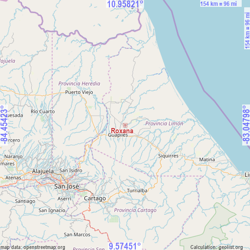
Roxana GPS coordinates[2]
10° 16' 1.632" North, 83° 45' 3.96" West
| Map corner | latitude | longitude |
|---|---|---|
| Upper-left | 10.95821°, | -84.45423° |
| Center: | 10.26712°, | -83.7511° |
| Lower-right: | 9.57451°, | -83.04798° |
| Map W x H: | 153.9×153.9 km | = 95.6×95.6mi |
| max Lat: | 11.07377° ⇑14.9% North |
| Roxana: | 10.26712° |
| min Lat: | ⇓85.1% South 8.53305° |
| min Long | Roxana | max Long |
| -85.64748° | -83.7511° | -82.62185° |
| W 82.1%⇐ | ⇒17.9% E |
Elevation
Elevation of Roxana is 118 m = 387 ft, and this is 617 m = 2024 ft below average elevation for this country.
| Max E: |
1844 m = 6050 ft | 78.4% |
| Avg. | 735 m = 2411 ft | |
| Roxana | 118 m = 387 ft | |
Min E: |
7 m = 23 ft | 21.6% |
See also: Costa Rica elevation on elevation.city.
Geographical zone
Roxana is located in North Torrid zone (between Equator and Tropic of Cancer). Distance of Equator is 1141.6 km =709.4 mi to South.| Distance of | km | miles | from Roxana |
|---|---|---|---|
| North Pole | 8865.5 | 5508.8 | to North |
| Arctic Circle | 6259.6 | 3889.5 | to North |
| Tropic Cancer | 1464.3 | 909.9 | to North |
| Equator | 1141.6 | 709.4 | to South |


Nearby cities:
15 places around Roxana: (largest is in red/bold)
• Capellades
38.6 km =24 mi,  185°
185°
• Cariari
10.1 km =6.3 mi,  9°
9°
• Concepción
46 km =28.6 mi,  216°
216°
• Cot
43.5 km =27 mi,  197°
197°
• Dulce Nombre de Jesus
27.9 km =17.3 mi,  242°
242°
• Guácimo
9.2 km =5.7 mi,  131°
131°
• Guápiles
6.7 km =4.2 mi,  213°
213°
• Ipís
44 km =27.3 mi, 220°
• Jiménez
11.3 km =7 mi, 192°
• La Virgen
44.4 km =27.6 mi,  289°
289°
• Pacuarito
35.8 km =22.2 mi,  120°
120°
• Pocora
19.2 km =11.9 mi, 123°
• Siquirres
32.7 km =20.3 mi, 125°
• Turrialba
41 km =25.5 mi,  169°
169°
• Ángeles
44.6 km =27.7 mi,  227°
227°
Sources, notices
• [Note1] Compared only with cities in Costa Rica existing in our database
• [Src1] Map data: © OpenStreetMap contributors (CC-BY-SA)
• [Src2] Other city data from geonames.org with taken over terms of usage.
• [Src3] Geographical zone / Annual Mean Temperature by Robert A. Rohde @ Wikipedia
