Cahuita geodata
Cahuita (Limón) is a populated place; located in Costa Rica in America/Costa_Rica (GMT-6) time zone. With population of 646 people, there are 123 cities with bigger population in this country. Compared to other cities in Costa Rica, 88.1% of cities are located further ↑North; 98.5% of cities are located further ←West and 100% of cities have higher elevation than Cahuita. Note1


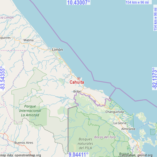
Cahuita GPS coordinates[2]
9° 44' 16.116" North, 82° 50' 25.512" West
| Map corner | latitude | longitude |
|---|---|---|
| Upper-left | 10.43007°, | -83.54355° |
| Center: | 9.73781°, | -82.84042° |
| Lower-right: | 9.04411°, | -82.1373° |
| Map W x H: | 154.1×154.1 km | = 95.8×95.8mi |
| max Lat: | 11.07377° ⇑88.1% North |
| Cahuita: | 9.73781° |
| min Lat: | ⇓11.9% South 8.53305° |
| min Long | Cahuita | max Long |
| -85.64748° | -82.84042° | -82.62185° |
| W 98.5%⇐ | ⇒1.5% E |
Elevation
Elevation of Cahuita is 7 m = 23 ft, and this is 728 m = 2388 ft below average elevation for this country.
| Max E: |
1844 m = 6050 ft | 100% |
| Avg. | 735 m = 2411 ft | |
| Cahuita | 7 m = 23 ft | |
Min E: |
7 m = 23 ft | 0% |
See also: Costa Rica elevation on elevation.city.
Geographical zone
Cahuita is located in North Torrid zone (between Equator and Tropic of Cancer). Distance of Equator is 1082.7 km =672.8 mi to South.| Distance of | km | miles | from Cahuita |
|---|---|---|---|
| North Pole | 8924.3 | 5545.3 | to North |
| Arctic Circle | 6318.4 | 3926.1 | to North |
| Tropic Cancer | 1523.2 | 946.5 | to North |
| Equator | 1082.7 | 672.8 | to South |


Nearby cities:
15 places around Cahuita: (largest is in red/bold)
• Batán
66.3 km =41.2 mi,  305°
305°
• Buenos Aires
83 km =51.6 mi,  220°
220°
• Daniel Flores
101.3 km =62.9 mi,  243°
243°
• La Suiza
86 km =53.4 mi,  278°
278°
• Limón
35.4 km =22 mi,  322°
322°
• Matina
62 km =38.5 mi, 308°
• Mercedes
97 km =60.3 mi, 236°
• Pacuarito
79.9 km =49.6 mi,  300°
300°
• Pejibaye
94.9 km =59 mi,  274°
274°
• Pocora
96.6 km =60 mi, 299°
• Sabalito
102.5 km =63.7 mi,  184°
184°
• Siquirres
83.2 km =51.7 mi, 298°
• Sixaola
33.5 km =20.8 mi,  134°
134°
• Tucurrique
97.5 km =60.6 mi, 277°
• Turrialba
94.2 km =58.5 mi, 281°
Sources, notices
• [Note1] Compared only with cities in Costa Rica existing in our database
• [Src1] Map data: © OpenStreetMap contributors (CC-BY-SA)
• [Src2] Other city data from geonames.org with taken over terms of usage.
• [Src3] Geographical zone / Annual Mean Temperature by Robert A. Rohde @ Wikipedia
