Assomada geodata
Assomada (Santa Catarina) is a seat of a first-order administrative division; located in Cape Verde in Atlantic/Cape_Verde (GMT-1) time zone. With population of 7,927 people, there are 7 cities with bigger population in this country. Compared to other cities in Cape Verde, 62.5% of cities are located further ↑North; 50% of cities are located further ←West and 91.7% of cities have lower elevation than Assomada. Note1


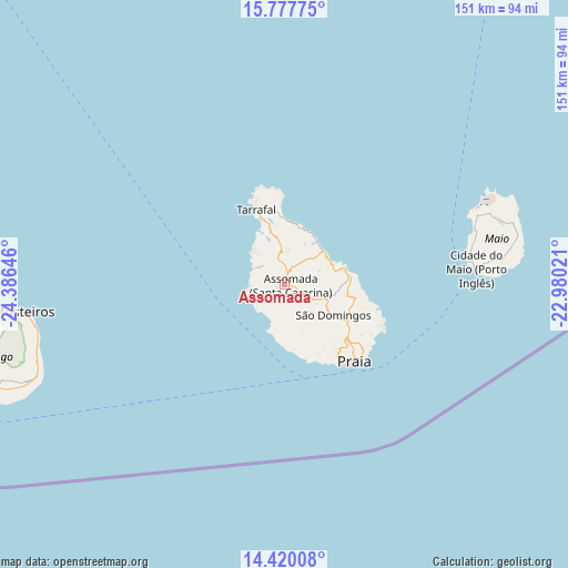
Assomada GPS coordinates[2]
15° 6' 0" North, 23° 40' 59.988" West
| Map corner | latitude | longitude |
|---|---|---|
| Upper-left | 15.77775°, | -24.38646° |
| Center: | 15.1°, | -23.68333° |
| Lower-right: | 14.42008°, | -22.98021° |
| Map W x H: | 151×151 km | = 93.8×93.8mi |
| max Lat: | 17.20171° ⇑62.5% North |
| Assomada: | 15.1° |
| min Lat: | ⇓37.5% South 14.87139° |
| min Long | Assomada | max Long |
| -25.09217° | -23.68333° | -22.90509° |
| W 50%⇐ | ⇒50% E |
Elevation
Elevation of Assomada is 391 m = 1283 ft, and this is 273.2 m = 896 ft above average elevation for this country.
| Max E: |
480 m = 1575 ft | 8.3% |
| Assomada | 391 m 1283 ft | |
| Avg. | 117.8 m = 386 ft | |
Min E: |
1 m = 3 ft | 91.7% |
See also: Cape Verde elevation on elevation.city.
Geographical zone
Assomada is located in North Torrid zone (between Equator and Tropic of Cancer). Distance of this Northern Tropic circle is 927 km =576 mi to North.| Distance of | km | miles | from Assomada |
|---|---|---|---|
| North Pole | 8328.1 | 5174.8 | to North |
| Arctic Circle | 5722.2 | 3555.6 | to North |
| Tropic Cancer | 927 | 576 | to North |
| Equator | 1679 | 1043.3 | to South |


Nearby cities:
15 places around Assomada: (largest is in red/bold)
• Calheta
13.7 km =8.5 mi,  45°
45°
• Cidade Velha
22.2 km =13.8 mi,  157°
157°
• Cova Figueira
69.5 km =43.2 mi,  250°
250°
• Igreja
69.3 km =43.1 mi,  263°
263°
• João Teves
10.8 km =6.7 mi,  109°
109°
• Nova Sintra
111.7 km =69.4 mi, 256°
• Pedra Badejo
16.9 km =10.5 mi,  75°
75°
• Picos
5.8 km =3.6 mi, 108°
• Praia
26.2 km =16.3 mi,  135°
135°
• Sal Rei
145.1 km =90.2 mi,  34°
34°
• Santa Cruz
13.1 km =8.1 mi,  73°
73°
• São Domingos
15.5 km =9.6 mi,  122°
122°
• São Filipe
90.1 km =56 mi, 255°
• Tarrafal
21.2 km =13.2 mi,  339°
339°
• Vila do Maio
50.8 km =31.6 mi,  85°
85°
Sources, notices
• [Note1] Compared only with cities in Cape Verde existing in our database
• [Src1] Map data: © OpenStreetMap contributors (CC-BY-SA)
• [Src2] Other city data from geonames.org with taken over terms of usage.
• [Src3] Geographical zone / Annual Mean Temperature by Robert A. Rohde @ Wikipedia
