Praia geodata
Praia is a capital of a political entity; located in Cape Verde in Atlantic/Cape_Verde (GMT-1) time zone. With population of 113,364 people, there are 0 cities with bigger population in this country. Compared to other cities in Cape Verde, 83.3% of cities are located further ↑North; 83.3% of cities are located further ←West and 66.7% of cities have higher elevation than Praia. Note1


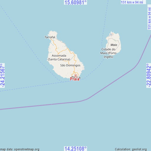
Praia GPS coordinates[2]
14° 55' 53.472" North, 23° 30' 45.144" West
| Map corner | latitude | longitude |
|---|---|---|
| Upper-left | 15.60981°, | -24.21567° |
| Center: | 14.93152°, | -23.51254° |
| Lower-right: | 14.25108°, | -22.80942° |
| Map W x H: | 151.1×151.1 km | = 93.9×93.9mi |
| max Lat: | 17.20171° ⇑83.3% North |
| Praia: | 14.93152° |
| min Lat: | ⇓16.7% South 14.87139° |
| min Long | Praia | max Long |
| -25.09217° | -23.51254° | -22.90509° |
| W 83.3%⇐ | ⇒16.7% E |
Elevation
Elevation of Praia is 18 m = 59 ft, and this is 99.8 m = 327 ft below average elevation for this country.
| Max E: |
480 m = 1575 ft | 66.7% |
| Avg. | 117.8 m = 386 ft | |
| Praia | 18 m = 59 ft | |
Min E: |
1 m = 3 ft | 33.3% |
See also: Praia elevation on elevation.city.
Geographical zone
Praia is located in North Torrid zone (between Equator and Tropic of Cancer). Distance of this Northern Tropic circle is 945.7 km =587.6 mi to North.| Distance of | km | miles | from Praia |
|---|---|---|---|
| North Pole | 8346.8 | 5186.5 | to North |
| Arctic Circle | 5740.9 | 3567.2 | to North |
| Tropic Cancer | 945.7 | 587.6 | to North |
| Equator | 1660.2 | 1031.6 | to South |


Nearby cities:
15 places around Praia: (largest is in red/bold)
• Assomada
26.2 km =16.3 mi,  315°
315°
• Calheta
29.6 km =18.4 mi,  343°
343°
• Cidade Velha
10.1 km =6.3 mi,  259°
259°
• Cova Figueira
84 km =52.2 mi,  266°
266°
• Igreja
88 km =54.7 mi,  277°
277°
• João Teves
17.2 km =10.7 mi,  331°
331°
• Nova Sintra
127.3 km =79.1 mi, 266°
• Pedra Badejo
23 km =14.3 mi,  355°
355°
• Picos
21.2 km =13.2 mi, 322°
• Sal Rei
152.4 km =94.7 mi,  24°
24°
• Santa Cruz
23.2 km =14.4 mi,  345°
345°
• São Domingos
11.6 km =7.2 mi, 332°
• São Filipe
105.7 km =65.7 mi, 267°
• Tarrafal
46.4 km =28.8 mi, 326°
• Vila do Maio
39.7 km =24.7 mi,  54°
54°
Sources, notices
• [Note1] Compared only with cities in Cape Verde existing in our database
• [Src1] Map data: © OpenStreetMap contributors (CC-BY-SA)
• [Src2] Other city data from geonames.org with taken over terms of usage.
• [Src3] Geographical zone / Annual Mean Temperature by Robert A. Rohde @ Wikipedia
