Cidade Velha geodata
Cidade Velha (Ribeira Grande de Santiago) is a seat of a first-order administrative division; located in Cape Verde in Atlantic/Cape_Verde (GMT-1) time zone. With population of 2,148 people, there are 18 cities with bigger population in this country. Compared to other cities in Cape Verde, 87.5% of cities are located further ↑North; 58.3% of cities are located further ←West and 91.7% of cities have higher elevation than Cidade Velha. Note1


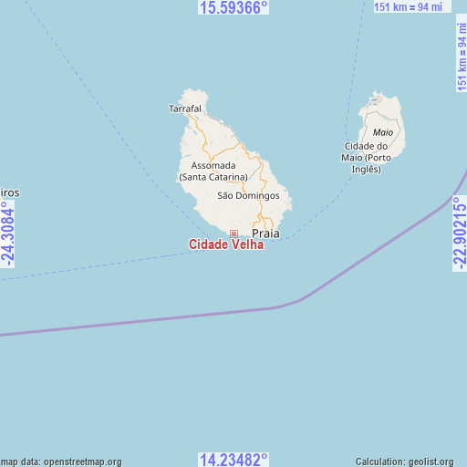
Cidade Velha GPS coordinates[2]
14° 54' 55.116" North, 23° 36' 18.972" West
| Map corner | latitude | longitude |
|---|---|---|
| Upper-left | 15.59366°, | -24.3084° |
| Center: | 14.91531°, | -23.60527° |
| Lower-right: | 14.23482°, | -22.90215° |
| Map W x H: | 151.1×151.1 km | = 93.9×93.9mi |
| max Lat: | 17.20171° ⇑87.5% North |
| Cidade Velha: | 14.91531° |
| min Lat: | ⇓12.5% South 14.87139° |
| min Long | Cidade Velha | max Long |
| -25.09217° | -23.60527° | -22.90509° |
| W 58.3%⇐ | ⇒41.7% E |
Elevation
Elevation of Cidade Velha is 5 m = 16 ft, and this is 112.8 m = 370 ft below average elevation for this country.
| Max E: |
480 m = 1575 ft | 91.7% |
| Avg. | 117.8 m = 386 ft | |
| Cidade Velha | 5 m = 16 ft | |
Min E: |
1 m = 3 ft | 8.3% |
See also: Cape Verde elevation on elevation.city.
Geographical zone
Cidade Velha is located in North Torrid zone (between Equator and Tropic of Cancer). Distance of this Northern Tropic circle is 947.5 km =588.7 mi to North.| Distance of | km | miles | from Cidade Velha |
|---|---|---|---|
| North Pole | 8348.6 | 5187.6 | to North |
| Arctic Circle | 5742.7 | 3568.3 | to North |
| Tropic Cancer | 947.5 | 588.7 | to North |
| Equator | 1658.4 | 1030.5 | to South |


Nearby cities:
15 places around Cidade Velha: (largest is in red/bold)
• Assomada
22.2 km =13.8 mi,  337°
337°
• Calheta
30.1 km =18.7 mi,  2°
2°
• Cova Figueira
74 km =46 mi,  267°
267°
• Igreja
78.4 km =48.7 mi,  279°
279°
• João Teves
16.9 km =10.5 mi,  5°
5°
• Nova Sintra
117.3 km =72.9 mi, 267°
• Pedra Badejo
26 km =16.2 mi,  17°
17°
• Picos
18.9 km =11.7 mi,  351°
351°
• Praia
10.1 km =6.3 mi,  79°
79°
• Sal Rei
158.4 km =98.4 mi,  27°
27°
• Santa Cruz
24.6 km =15.3 mi, 9°
• São Domingos
13 km =8.1 mi, 20°
• São Filipe
95.7 km =59.5 mi, 268°
• Tarrafal
43.4 km =27 mi, 338°
• Vila do Maio
49 km =30.4 mi,  59°
59°
Sources, notices
• [Note1] Compared only with cities in Cape Verde existing in our database
• [Src1] Map data: © OpenStreetMap contributors (CC-BY-SA)
• [Src2] Other city data from geonames.org with taken over terms of usage.
• [Src3] Geographical zone / Annual Mean Temperature by Robert A. Rohde @ Wikipedia
