Santa Cruz geodata
Santa Cruz is a populated place; located in Cape Verde in Atlantic/Cape_Verde (GMT-1) time zone. With population of 9,488 people, there are 4 cities with bigger population in this country. Compared to other cities in Cape Verde, 58.3% of cities are located further ↑North; 70.8% of cities are located further ←West and 58.3% of cities have lower elevation than Santa Cruz. Note1


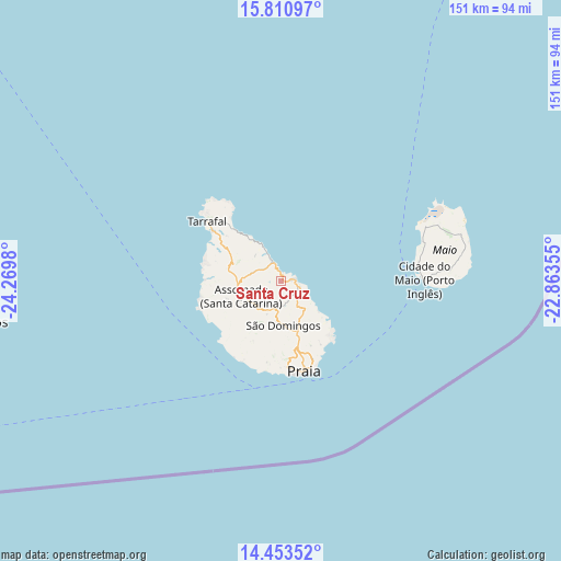
Santa Cruz GPS coordinates[2]
15° 7' 59.988" North, 23° 34' 0.012" West
| Map corner | latitude | longitude |
|---|---|---|
| Upper-left | 15.81097°, | -24.2698° |
| Center: | 15.13333°, | -23.56667° |
| Lower-right: | 14.45352°, | -22.86355° |
| Map W x H: | 150.9×150.9 km | = 93.8×93.8mi |
| max Lat: | 17.20171° ⇑58.3% North |
| Santa Cruz: | 15.13333° |
| min Lat: | ⇓41.7% South 14.87139° |
| min Long | Santa Cruz | max Long |
| -25.09217° | -23.56667° | -22.90509° |
| W 70.8%⇐ | ⇒29.2% E |
Elevation
Elevation of Santa Cruz is 45 m = 148 ft, and this is 72.8 m = 239 ft below average elevation for this country.
| Max E: |
480 m = 1575 ft | 41.7% |
| Avg. | 117.8 m = 386 ft | |
| Santa Cruz | 45 m = 148 ft | |
Min E: |
1 m = 3 ft | 58.3% |
See also: Cape Verde elevation on elevation.city.
Geographical zone
Santa Cruz is located in North Torrid zone (between Equator and Tropic of Cancer). Distance of this Northern Tropic circle is 923.3 km =573.7 mi to North.| Distance of | km | miles | from Santa Cruz |
|---|---|---|---|
| North Pole | 8324.4 | 5172.5 | to North |
| Arctic Circle | 5718.5 | 3553.3 | to North |
| Tropic Cancer | 923.3 | 573.7 | to North |
| Equator | 1682.7 | 1045.6 | to South |


Nearby cities:
15 places around Santa Cruz: (largest is in red/bold)
• Assomada
13.1 km =8.1 mi,  253°
253°
• Calheta
6.5 km =4 mi,  334°
334°
• Cidade Velha
24.6 km =15.3 mi,  189°
189°
• Cova Figueira
82.6 km =51.3 mi, 250°
• Igreja
82.2 km =51.1 mi,  262°
262°
• João Teves
7.8 km =4.8 mi,  198°
198°
• Nova Sintra
124.7 km =77.5 mi, 256°
• Pedra Badejo
3.9 km =2.4 mi,  83°
83°
• Picos
9 km =5.6 mi,  231°
231°
• Praia
23.2 km =14.4 mi,  165°
165°
• Sal Rei
135.2 km =84 mi,  30°
30°
• São Domingos
12.1 km =7.5 mi,  177°
177°
• São Filipe
103.2 km =64.1 mi, 255°
• Tarrafal
25.6 km =15.9 mi,  309°
309°
• Vila do Maio
38.1 km =23.7 mi,  89°
89°
Sources, notices
• [Note1] Compared only with cities in Cape Verde existing in our database
• [Src1] Map data: © OpenStreetMap contributors (CC-BY-SA)
• [Src2] Other city data from geonames.org with taken over terms of usage.
• [Src3] Geographical zone / Annual Mean Temperature by Robert A. Rohde @ Wikipedia
