Bautzen geodata
Bautzen (Saxony) is a seat of a third-order administrative division; located in Germany in Europe/Berlin (GMT+2) time zone. With population of 41,972 people, there are 299 cities with bigger population in this country. Compared to other cities in Germany, 61.2% of cities are located further ↓South; 99.2% of cities are located further ←West and 51.8% of cities have higher elevation than Bautzen. Note1


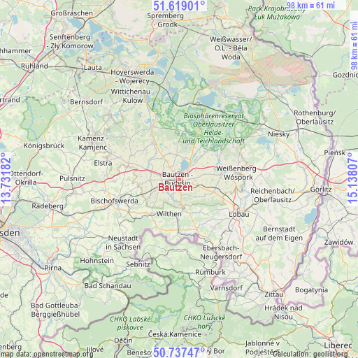
Bautzen GPS coordinates[2]
51° 10' 49.26" North, 14° 26' 5.784" East
| Map corner | latitude | longitude |
|---|---|---|
| Upper-left | 51.61901°, | 13.73182° |
| Center: | 51.18035°, | 14.43494° |
| Lower-right: | 50.73747°, | 15.13807° |
| Map W x H: | 98×98 km | = 60.9×60.9mi |
| max Lat: | 55.01917° ⇑38.8% North |
| Bautzen: | 51.18035° |
| min Lat: | ⇓61.2% South 47.40724° |
| min Long | Bautzen | max Long |
| 5.92978° | 14.43494° | 14.98853° |
| W 99.2%⇐ | ⇒0.8% E |
Elevation
Elevation of Bautzen is 213 m = 699 ft, and this is 36.1 m = 118 ft below average elevation for this country.
| Max E: |
1256 m = 4121 ft | 51.8% |
| Avg. | 249.1 m = 817 ft | |
| Bautzen | 213 m = 699 ft | |
Min E: |
-5 m = -16 ft | 48.2% |
See also: Bautzen elevation on elevation.city.
Geographical zone
Bautzen is located in North temperate zone (between Tropic of Cancer and the Arctic Circle). Distance of this North polar circle is 1710.5 km =1062.9 mi to North.| Distance of | km | miles | from Bautzen |
|---|---|---|---|
| North Pole | 4316.3 | 2682 | to North |
| Arctic Circle | 1710.5 | 1062.9 | to North |
| Tropic Cancer | 3084.8 | 1916.8 | to South |
| Equator | 5690.7 | 3536 | to South |


Nearby cities:
15 places around Bautzen: (largest is in red/bold)
• Crostau
10.7 km =6.6 mi,  172°
172°
• Cunewalde
10.6 km =6.6 mi,  147°
147°
• Großdubrau
8.4 km =5.2 mi,  11°
11°
• Großpostwitz
6.6 km =4.1 mi,  176°
176°
• Guttau
12.4 km =7.7 mi,  45°
45°
• Göda
8.1 km =5 mi,  268°
268°
• Hochkirch
10.1 km =6.3 mi,  110°
110°
• Kirschau
9.7 km =6 mi, 182°
• Kubschütz
4.8 km =3 mi, 108°
• Malschwitz
8.8 km =5.5 mi,  43°
43°
• Obergurig
5.7 km =3.5 mi,  201°
201°
• Puschwitz
12.5 km =7.8 mi,  311°
311°
• Radibor
7.6 km =4.7 mi,  340°
340°
• Schirgiswalde
11.6 km =7.2 mi, 182°
• Wilthen
9.7 km =6 mi, 197°
Sources, notices
• [Note1] Compared only with cities in Germany existing in our database
• [Src1] Map data: © OpenStreetMap contributors (CC-BY-SA)
• [Src2] Other city data from geonames.org with taken over terms of usage.
• [Src3] Geographical zone / Annual Mean Temperature by Robert A. Rohde @ Wikipedia
