Veilsdorf geodata
Veilsdorf (Thuringia) is a seat of a fourth-order administrative division; located in Germany in Europe/Berlin (GMT+2) time zone. With population of 3,225 people, there are 3812 cities with bigger population in this country. Compared to other cities in Germany, 54.4% of cities are located further ↑North; 64.2% of cities are located further ←West and 74.6% of cities have lower elevation than Veilsdorf. Note1


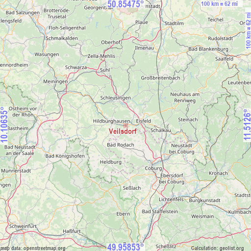
Veilsdorf GPS coordinates[2]
50° 24' 31.536" North, 10° 48' 34.092" East
| Map corner | latitude | longitude |
|---|---|---|
| Upper-left | 50.85475°, | 10.10635° |
| Center: | 50.40876°, | 10.80947° |
| Lower-right: | 49.95853°, | 11.5126° |
| Map W x H: | 99.7×99.6 km | = 62×61.9mi |
| max Lat: | 55.01917° ⇑54.4% North |
| Veilsdorf: | 50.40876° |
| min Lat: | ⇓45.6% South 47.40724° |
| min Long | Veilsdorf | max Long |
| 5.92978° | 10.80947° | 14.98853° |
| W 64.2%⇐ | ⇒35.8% E |
Elevation
Elevation of Veilsdorf is 394 m = 1293 ft, and this is 144.9 m = 475 ft above average elevation for this country.
| Max E: |
1256 m = 4121 ft | 25.4% |
| Veilsdorf | 394 m 1293 ft | |
| Avg. | 249.1 m = 817 ft | |
Min E: |
-5 m = -16 ft | 74.6% |
See also: Germany elevation on elevation.city.
Geographical zone
Veilsdorf is located in North temperate zone (between Tropic of Cancer and the Arctic Circle). Distance of this North polar circle is 1796.2 km =1116.1 mi to North.| Distance of | km | miles | from Veilsdorf |
|---|---|---|---|
| North Pole | 4402.1 | 2735.3 | to North |
| Arctic Circle | 1796.2 | 1116.1 | to North |
| Tropic Cancer | 2999 | 1863.5 | to South |
| Equator | 5604.9 | 3482.7 | to South |


Nearby cities:
15 places around Veilsdorf: (largest is in red/bold)
• Bachfeld
12.4 km =7.7 mi,  85°
85°
• Bockstadt
5.3 km =3.3 mi,  100°
100°
• Dingsleben
15.1 km =9.4 mi,  280°
280°
• Ehrenberg
14 km =8.7 mi,  306°
306°
• Eisfeld
7.2 km =4.5 mi,  74°
74°
• Grimmelshausen
15 km =9.3 mi,  303°
303°
• Hildburghausen
5.8 km =3.6 mi,  288°
288°
• Lautertal
14 km =8.7 mi,  126°
126°
• Meeder
11.9 km =7.4 mi,  144°
144°
• Reurieth
12.2 km =7.6 mi, 292°
• Sachsenbrunn
10.8 km =6.7 mi, 66°
• Sankt Kilian
13.6 km =8.5 mi,  346°
346°
• Schalkau
14.1 km =8.8 mi, 96°
• Schleusingen
11.9 km =7.4 mi,  341°
341°
• Westhausen
14.7 km =9.1 mi,  225°
225°
Sources, notices
• [Note1] Compared only with cities in Germany existing in our database
• [Src1] Map data: © OpenStreetMap contributors (CC-BY-SA)
• [Src2] Other city data from geonames.org with taken over terms of usage.
• [Src3] Geographical zone / Annual Mean Temperature by Robert A. Rohde @ Wikipedia
