Königstein geodata
Königstein (Bavaria) is a populated place; located in Germany in Europe/Berlin (GMT+2) time zone. With population of 1,761 people, there are 5411 cities with bigger population in this country. Compared to other cities in Germany, 73.6% of cities are located further ↑North; 76.2% of cities are located further ←West and 88.1% of cities have lower elevation than Königstein. Note1
Administrative division(s):
- Level 1: Bavaria
- Level 2: Upper Palatinate
- Level 3: Landkreis Amberg-Sulzbach
- Level 4: Königstein, Markt


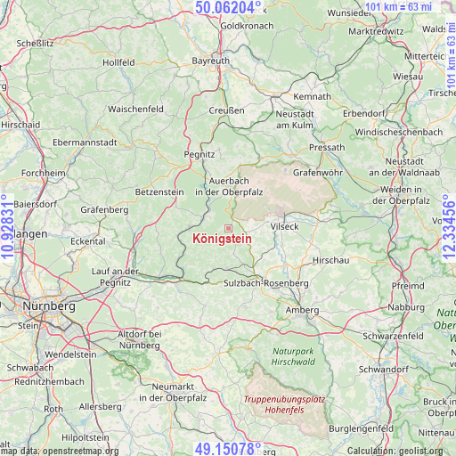
Königstein GPS coordinates[2]
49° 36' 30.744" North, 11° 37' 53.148" East
| Map corner | latitude | longitude |
|---|---|---|
| Upper-left | 50.06204°, | 10.92831° |
| Center: | 49.60854°, | 11.63143° |
| Lower-right: | 49.15078°, | 12.33456° |
| Map W x H: | 101.3×101.3 km | = 62.9×62.9mi |
| max Lat: | 55.01917° ⇑73.6% North |
| Königstein: | 49.60854° |
| min Lat: | ⇓26.4% South 47.40724° |
| min Long | Königstein | max Long |
| 5.92978° | 11.63143° | 14.98853° |
| W 76.2%⇐ | ⇒23.8% E |
Elevation
Elevation of Königstein is 495 m = 1624 ft, and this is 245.9 m = 807 ft above average elevation for this country.
| Max E: |
1256 m = 4121 ft | 11.9% |
| Königstein | 495 m 1624 ft | |
| Avg. | 249.1 m = 817 ft | |
Min E: |
-5 m = -16 ft | 88.1% |
See also: Germany elevation on elevation.city.
Geographical zone
Königstein is located in North temperate zone (between Tropic of Cancer and the Arctic Circle). Distance of this North polar circle is 1885.2 km =1171.4 mi to North.| Distance of | km | miles | from Königstein |
|---|---|---|---|
| North Pole | 4491.1 | 2790.6 | to North |
| Arctic Circle | 1885.2 | 1171.4 | to North |
| Tropic Cancer | 2910 | 1808.2 | to South |
| Equator | 5516 | 3427.5 | to South |


Nearby cities:
15 places around Königstein: (largest is in red/bold)
• Auerbach
9.3 km =5.8 mi,  0°
0°
• Edelsfeld
5.9 km =3.7 mi,  127°
127°
• Etzelwang
9.6 km =6 mi,  199°
199°
• Hahnbach
14.9 km =9.3 mi,  123°
123°
• Hartenstein
8.3 km =5.2 mi,  263°
263°
• Hirschbach
9.6 km =6 mi,  227°
227°
• Kirchensittenbach
16.2 km =10.1 mi,  248°
248°
• Kirchenthumbach
17 km =10.6 mi,  23°
23°
• Neuhaus an der Pegnitz
6.2 km =3.9 mi,  290°
290°
• Pommelsbrunn
14.5 km =9 mi,  216°
216°
• Sulzbach-Rosenberg
14.5 km =9 mi,  145°
145°
• Velden
8.8 km =5.5 mi,  273°
273°
• Vilseck
12.4 km =7.7 mi,  86°
86°
• Vorra
11.4 km =7.1 mi,  240°
240°
• Weigendorf
13.1 km =8.1 mi, 200°
Sources, notices
• [Note1] Compared only with cities in Germany existing in our database
• [Src1] Map data: © OpenStreetMap contributors (CC-BY-SA)
• [Src2] Other city data from geonames.org with taken over terms of usage.
• [Src3] Geographical zone / Annual Mean Temperature by Robert A. Rohde @ Wikipedia
