Cornberg geodata
Cornberg (Hesse) is a seat of a fourth-order administrative division; located in Germany in Europe/Berlin (GMT+2) time zone. With population of 1,621 people, there are 5652 cities with bigger population in this country. Compared to other cities in Germany, 58.8% of cities are located further ↓South; 52% of cities are located further →East and 59.8% of cities have lower elevation than Cornberg. Note1
Administrative division(s):
- Level 1: Hesse
- Level 2: Regierungsbezirk Kassel
- Level 3: Landkreis Hersfeld-Rotenburg
- Level 4: Cornberg


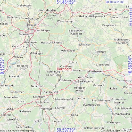
Cornberg GPS coordinates[2]
51° 2' 29.76" North, 9° 51' 37.836" East
| Map corner | latitude | longitude |
|---|---|---|
| Upper-left | 51.48159°, | 9.15739° |
| Center: | 51.0416°, | 9.86051° |
| Lower-right: | 50.59739°, | 10.56364° |
| Map W x H: | 98.3×98.3 km | = 61.1×61.1mi |
| max Lat: | 55.01917° ⇑41.2% North |
| Cornberg: | 51.0416° |
| min Lat: | ⇓58.8% South 47.40724° |
| min Long | Cornberg | max Long |
| 5.92978° | 9.86051° | 14.98853° |
| W 48%⇐ | ⇒52% E |
Elevation
Elevation of Cornberg is 289 m = 948 ft, and this is 39.9 m = 131 ft above average elevation for this country.
| Max E: |
1256 m = 4121 ft | 40.2% |
| Cornberg | 289 m 948 ft | |
| Avg. | 249.1 m = 817 ft | |
Min E: |
-5 m = -16 ft | 59.8% |
See also: Germany elevation on elevation.city.
Geographical zone
Cornberg is located in North temperate zone (between Tropic of Cancer and the Arctic Circle). Distance of this North polar circle is 1725.9 km =1072.4 mi to North.| Distance of | km | miles | from Cornberg |
|---|---|---|---|
| North Pole | 4331.8 | 2691.7 | to North |
| Arctic Circle | 1725.9 | 1072.4 | to North |
| Tropic Cancer | 3069.4 | 1907.2 | to South |
| Equator | 5675.3 | 3526.5 | to South |


Nearby cities:
15 places around Cornberg: (largest is in red/bold)
• Alheim
13.6 km =8.5 mi,  266°
266°
• Bebra
8.7 km =5.4 mi,  211°
211°
• Breitenbach
10.9 km =6.8 mi, 209°
• Dankmarshausen
16.9 km =10.5 mi,  139°
139°
• Dippach
18.6 km =11.6 mi, 136°
• Friedewald
17.6 km =10.9 mi,  178°
178°
• Gerstungen
16.7 km =10.4 mi,  120°
120°
• Großensee
14.1 km =8.8 mi,  148°
148°
• Heringen
19.9 km =12.4 mi, 148°
• Nentershausen
5.8 km =3.6 mi, 118°
• Ronshausen
10.2 km =6.3 mi, 184°
• Rotenburg an der Fulda
10.6 km =6.6 mi,  241°
241°
• Sontra
6.2 km =3.9 mi,  57°
57°
• Spangenberg
16.1 km =10 mi,  301°
301°
• Waldkappel
11.5 km =7.1 mi,  5°
5°
Sources, notices
• [Note1] Compared only with cities in Germany existing in our database
• [Src1] Map data: © OpenStreetMap contributors (CC-BY-SA)
• [Src2] Other city data from geonames.org with taken over terms of usage.
• [Src3] Geographical zone / Annual Mean Temperature by Robert A. Rohde @ Wikipedia
