Maintal geodata
Maintal (Hesse) is a populated place; located in Germany in Europe/Berlin (GMT+2) time zone. With population of 38,313 people, there are 344 cities with bigger population in this country. Compared to other cities in Germany, 60.2% of cities are located further ↑North; 67.5% of cities are located further →East and 67.1% of cities have higher elevation than Maintal. Note1
Administrative division(s):
- Level 1: Hesse
- Level 2: Regierungsbezirk Darmstadt
- Level 3: Main-Kinzig-Kreis
- Level 4: Maintal


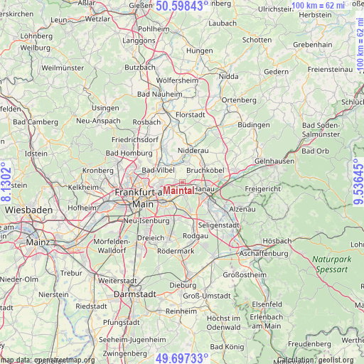
Maintal GPS coordinates[2]
50° 9' 0" North, 8° 49' 59.988" East
| Map corner | latitude | longitude |
|---|---|---|
| Upper-left | 50.59843°, | 8.1302° |
| Center: | 50.15°, | 8.83333° |
| Lower-right: | 49.69733°, | 9.53645° |
| Map W x H: | 100.2×100.2 km | = 62.3×62.3mi |
| max Lat: | 55.01917° ⇑60.2% North |
| Maintal: | 50.15° |
| min Lat: | ⇓39.8% South 47.40724° |
| min Long | Maintal | max Long |
| 5.92978° | 8.83333° | 14.98853° |
| W 32.5%⇐ | ⇒67.5% E |
Elevation
Elevation of Maintal is 107 m = 351 ft, and this is 142.1 m = 466 ft below average elevation for this country.
| Max E: |
1256 m = 4121 ft | 67.1% |
| Avg. | 249.1 m = 817 ft | |
| Maintal | 107 m = 351 ft | |
Min E: |
-5 m = -16 ft | 32.9% |
See also: Germany elevation on elevation.city.
Geographical zone
Maintal is located in North temperate zone (between Tropic of Cancer and the Arctic Circle). Distance of this North polar circle is 1825 km =1134 mi to North.| Distance of | km | miles | from Maintal |
|---|---|---|---|
| North Pole | 4430.9 | 2753.2 | to North |
| Arctic Circle | 1825 | 1134 | to North |
| Tropic Cancer | 2970.2 | 1845.6 | to South |
| Equator | 5576.2 | 3464.9 | to South |


Nearby cities:
15 places around Maintal: (largest is in red/bold)
• Bad Vilbel
7.5 km =4.7 mi,  295°
295°
• Bruchköbel
7.1 km =4.4 mi,  63°
63°
• Erlensee
10.4 km =6.5 mi,  82°
82°
• Frankfurt am Main
11.3 km =7 mi,  250°
250°
• Großkrotzenburg
13 km =8.1 mi,  124°
124°
• Hammersbach
13 km =8.1 mi, 55°
• Hanau am Main
6 km =3.7 mi,  106°
106°
• Heusenstamm
10.8 km =6.7 mi,  192°
192°
• Karben
9.9 km =6.2 mi,  333°
333°
• Mühlheim am Main
3.7 km =2.3 mi,  180°
180°
• Nidderau
10.1 km =6.3 mi,  13°
13°
• Niederdorfelden
5.5 km =3.4 mi, 334°
• Obertshausen
8.8 km =5.5 mi,  171°
171°
• Offenbach
7.3 km =4.5 mi,  220°
220°
• Rodenbach
14.2 km =8.8 mi,  90°
90°
Sources, notices
• [Note1] Compared only with cities in Germany existing in our database
• [Src1] Map data: © OpenStreetMap contributors (CC-BY-SA)
• [Src2] Other city data from geonames.org with taken over terms of usage.
• [Src3] Geographical zone / Annual Mean Temperature by Robert A. Rohde @ Wikipedia
