Niederdorfelden geodata
Niederdorfelden (Hesse) is a seat of a fourth-order administrative division; located in Germany in Europe/Berlin (GMT+2) time zone. With population of 2,925 people, there are 4066 cities with bigger population in this country. Compared to other cities in Germany, 59.1% of cities are located further ↑North; 67.9% of cities are located further →East and 65.6% of cities have higher elevation than Niederdorfelden. Note1
Administrative division(s):
- Level 1: Hesse
- Level 2: Regierungsbezirk Darmstadt
- Level 3: Main-Kinzig-Kreis
- Level 4: Niederdorfelden


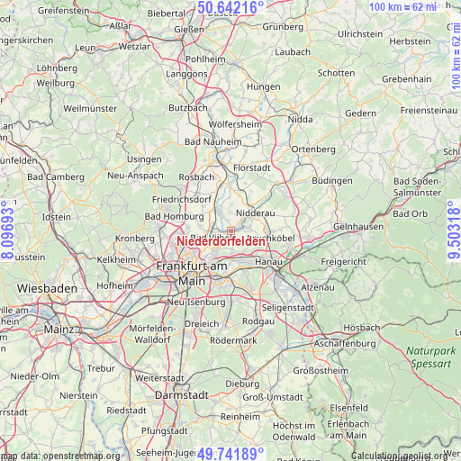
Niederdorfelden GPS coordinates[2]
50° 11' 38.94" North, 8° 48' 0.18" East
| Map corner | latitude | longitude |
|---|---|---|
| Upper-left | 50.64216°, | 8.09693° |
| Center: | 50.19415°, | 8.80005° |
| Lower-right: | 49.74189°, | 9.50318° |
| Map W x H: | 100.1×100.1 km | = 62.2×62.2mi |
| max Lat: | 55.01917° ⇑59.1% North |
| Niederdorfelden: | 50.19415° |
| min Lat: | ⇓40.9% South 47.40724° |
| min Long | Niederdorfelden | max Long |
| 5.92978° | 8.80005° | 14.98853° |
| W 32.1%⇐ | ⇒67.9% E |
Elevation
Elevation of Niederdorfelden is 117 m = 384 ft, and this is 132.1 m = 433 ft below average elevation for this country.
| Max E: |
1256 m = 4121 ft | 65.6% |
| Avg. | 249.1 m = 817 ft | |
| Niederdorfelden | 117 m = 384 ft | |
Min E: |
-5 m = -16 ft | 34.4% |
See also: Germany elevation on elevation.city.
Geographical zone
Niederdorfelden is located in North temperate zone (between Tropic of Cancer and the Arctic Circle). Distance of this North polar circle is 1820.1 km =1131 mi to North.| Distance of | km | miles | from Niederdorfelden |
|---|---|---|---|
| North Pole | 4426 | 2750.2 | to North |
| Arctic Circle | 1820.1 | 1131 | to North |
| Tropic Cancer | 2975.1 | 1848.6 | to South |
| Equator | 5581.1 | 3467.9 | to South |


Nearby cities:
15 places around Niederdorfelden: (largest is in red/bold)
• Bad Homburg vor der Höhe
13.4 km =8.3 mi,  285°
285°
• Bad Vilbel
4.8 km =3 mi,  248°
248°
• Bruchköbel
8.9 km =5.5 mi,  101°
101°
• Erlensee
13.2 km =8.2 mi,  105°
105°
• Florstadt
14.4 km =8.9 mi,  19°
19°
• Frankfurt am Main
12 km =7.5 mi,  223°
223°
• Friedrichsdorf
12.8 km =8 mi,  298°
298°
• Hammersbach
13.3 km =8.3 mi,  79°
79°
• Hanau am Main
10.5 km =6.5 mi,  129°
129°
• Karben
4.5 km =2.8 mi,  333°
333°
• Maintal
5.5 km =3.4 mi,  154°
154°
• Mühlheim am Main
8.9 km =5.5 mi,  164°
164°
• Nidderau
6.8 km =4.2 mi,  44°
44°
• Obertshausen
14.1 km =8.8 mi,  165°
165°
• Offenbach
10.7 km =6.6 mi,  192°
192°
Sources, notices
• [Note1] Compared only with cities in Germany existing in our database
• [Src1] Map data: © OpenStreetMap contributors (CC-BY-SA)
• [Src2] Other city data from geonames.org with taken over terms of usage.
• [Src3] Geographical zone / Annual Mean Temperature by Robert A. Rohde @ Wikipedia
