Bennungen geodata
Bennungen (Saxony-Anhalt) is a populated place; located in Germany in Europe/Berlin (GMT+2) time zone. With population of 1,004 people, there are 7165 cities with bigger population in this country. Compared to other cities in Germany, 65.7% of cities are located further ↓South; 68.7% of cities are located further ←West and 60.6% of cities have higher elevation than Bennungen. Note1


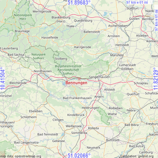
Bennungen GPS coordinates[2]
51° 27' 39.06" North, 11° 7' 5.376" East
| Map corner | latitude | longitude |
|---|---|---|
| Upper-left | 51.89683°, | 10.41504° |
| Center: | 51.46085°, | 11.11816° |
| Lower-right: | 51.02066°, | 11.82129° |
| Map W x H: | 97.4×97.4 km | = 60.5×60.5mi |
| max Lat: | 55.01917° ⇑34.3% North |
| Bennungen: | 51.46085° |
| min Lat: | ⇓65.7% South 47.40724° |
| min Long | Bennungen | max Long |
| 5.92978° | 11.11816° | 14.98853° |
| W 68.7%⇐ | ⇒31.3% E |
Elevation
Elevation of Bennungen is 148 m = 486 ft, and this is 101.1 m = 332 ft below average elevation for this country.
| Max E: |
1256 m = 4121 ft | 60.6% |
| Avg. | 249.1 m = 817 ft | |
| Bennungen | 148 m = 486 ft | |
Min E: |
-5 m = -16 ft | 39.4% |
See also: Germany elevation on elevation.city.
Geographical zone
Bennungen is located in North temperate zone (between Tropic of Cancer and the Arctic Circle). Distance of this North polar circle is 1679.3 km =1043.5 mi to North.| Distance of | km | miles | from Bennungen |
|---|---|---|---|
| North Pole | 4285.2 | 2662.7 | to North |
| Arctic Circle | 1679.3 | 1043.5 | to North |
| Tropic Cancer | 3116 | 1936.2 | to South |
| Equator | 5721.9 | 3555.4 | to South |


Nearby cities:
15 places around Bennungen: (largest is in red/bold)
• Bad Frankenhausen
11.7 km =7.3 mi,  186°
186°
• Badra
11.6 km =7.2 mi,  238°
238°
• Berga
7.7 km =4.8 mi,  265°
265°
• Borxleben
10.5 km =6.5 mi,  130°
130°
• Breitungen
6.2 km =3.9 mi,  311°
311°
• Brücken
5.8 km =3.6 mi,  108°
108°
• Ichstedt
10.3 km =6.4 mi,  146°
146°
• Kelbra
6 km =3.7 mi, 241°
• Riethnordhausen
9.3 km =5.8 mi,  118°
118°
• Rottleben
12 km =7.5 mi,  204°
204°
• Roßla
2.9 km =1.8 mi,  275°
275°
• Steinthaleben
9.8 km =6.1 mi,  221°
221°
• Tilleda
4.8 km =3 mi,  160°
160°
• Uftrungen
10.4 km =6.5 mi,  293°
293°
• Wallhausen
6.2 km =3.9 mi,  89°
89°
Sources, notices
• [Note1] Compared only with cities in Germany existing in our database
• [Src1] Map data: © OpenStreetMap contributors (CC-BY-SA)
• [Src2] Other city data from geonames.org with taken over terms of usage.
• [Src3] Geographical zone / Annual Mean Temperature by Robert A. Rohde @ Wikipedia
