Roßla geodata
Roßla (Saxony-Anhalt) is a populated place; located in Germany in Europe/Berlin (GMT+2) time zone. With population of 2,378 people, there are 4579 cities with bigger population in this country. Compared to other cities in Germany, 65.8% of cities are located further ↓South; 68% of cities are located further ←West and 59.7% of cities have higher elevation than Roßla. Note1


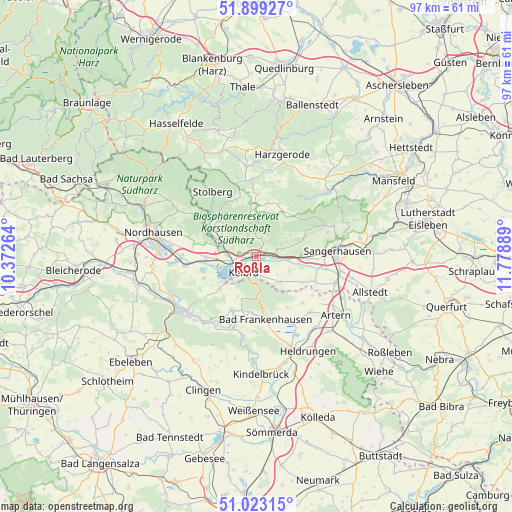
Roßla GPS coordinates[2]
51° 27' 47.916" North, 11° 4' 32.736" East
| Map corner | latitude | longitude |
|---|---|---|
| Upper-left | 51.89927°, | 10.37264° |
| Center: | 51.46331°, | 11.07576° |
| Lower-right: | 51.02315°, | 11.77889° |
| Map W x H: | 97.4×97.4 km | = 60.5×60.5mi |
| max Lat: | 55.01917° ⇑34.2% North |
| Roßla: | 51.46331° |
| min Lat: | ⇓65.8% South 47.40724° |
| min Long | Roßla | max Long |
| 5.92978° | 11.07576° | 14.98853° |
| W 68%⇐ | ⇒32% E |
Elevation
Elevation of Roßla is 155 m = 509 ft, and this is 94.1 m = 309 ft below average elevation for this country.
| Max E: |
1256 m = 4121 ft | 59.7% |
| Avg. | 249.1 m = 817 ft | |
| Roßla | 155 m = 509 ft | |
Min E: |
-5 m = -16 ft | 40.3% |
See also: Germany elevation on elevation.city.
Geographical zone
Roßla is located in North temperate zone (between Tropic of Cancer and the Arctic Circle). Distance of this North polar circle is 1679 km =1043.3 mi to North.| Distance of | km | miles | from Roßla |
|---|---|---|---|
| North Pole | 4284.9 | 2662.5 | to North |
| Arctic Circle | 1679 | 1043.3 | to North |
| Tropic Cancer | 3116.3 | 1936.4 | to South |
| Equator | 5722.2 | 3555.6 | to South |


Nearby cities:
15 places around Roßla: (largest is in red/bold)
• Auleben
10.9 km =6.8 mi,  247°
247°
• Badra
9.4 km =5.8 mi,  228°
228°
• Bendeleben
11.2 km =7 mi,  205°
205°
• Bennungen
2.9 km =1.8 mi,  95°
95°
• Berga
4.8 km =3 mi,  259°
259°
• Breitungen
4.2 km =2.6 mi,  336°
336°
• Brücken
8.7 km =5.4 mi, 104°
• Görsbach
9.6 km =6 mi,  269°
269°
• Kelbra
3.9 km =2.4 mi,  217°
217°
• Rottleben
11.4 km =7.1 mi,  189°
189°
• Rottleberode
10.7 km =6.6 mi,  303°
303°
• Steinthaleben
8.4 km =5.2 mi,  204°
204°
• Tilleda
6.6 km =4.1 mi,  136°
136°
• Uftrungen
7.7 km =4.8 mi, 300°
• Wallhausen
9.1 km =5.7 mi,  91°
91°
Sources, notices
• [Note1] Compared only with cities in Germany existing in our database
• [Src1] Map data: © OpenStreetMap contributors (CC-BY-SA)
• [Src2] Other city data from geonames.org with taken over terms of usage.
• [Src3] Geographical zone / Annual Mean Temperature by Robert A. Rohde @ Wikipedia
