Langenmosen geodata
Langenmosen (Bavaria) is a seat of a fourth-order administrative division; located in Germany in Europe/Berlin (GMT+2) time zone. With population of 1,496 people, there are 5889 cities with bigger population in this country. Compared to other cities in Germany, 87.7% of cities are located further ↑North; 70.1% of cities are located further ←West and 75.7% of cities have lower elevation than Langenmosen. Note1
Administrative division(s):
- Level 1: Bavaria
- Level 2: Upper Bavaria
- Level 3: Landkreis Neuburg-Schrobenhausen
- Level 4: Langenmosen


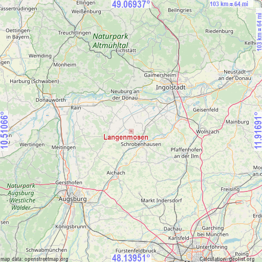
Langenmosen GPS coordinates[2]
48° 36' 23.688" North, 11° 12' 49.608" East
| Map corner | latitude | longitude |
|---|---|---|
| Upper-left | 49.06937°, | 10.51066° |
| Center: | 48.60658°, | 11.21378° |
| Lower-right: | 48.13951°, | 11.91691° |
| Map W x H: | 103.4×103.4 km | = 64.2×64.2mi |
| max Lat: | 55.01917° ⇑87.7% North |
| Langenmosen: | 48.60658° |
| min Lat: | ⇓12.3% South 47.40724° |
| min Long | Langenmosen | max Long |
| 5.92978° | 11.21378° | 14.98853° |
| W 70.1%⇐ | ⇒29.9% E |
Elevation
Elevation of Langenmosen is 403 m = 1322 ft, and this is 153.9 m = 505 ft above average elevation for this country.
| Max E: |
1256 m = 4121 ft | 24.3% |
| Langenmosen | 403 m 1322 ft | |
| Avg. | 249.1 m = 817 ft | |
Min E: |
-5 m = -16 ft | 75.7% |
See also: Germany elevation on elevation.city.
Geographical zone
Langenmosen is located in North temperate zone (between Tropic of Cancer and the Arctic Circle). Distance of this North polar circle is 1996.6 km =1240.6 mi to North.| Distance of | km | miles | from Langenmosen |
|---|---|---|---|
| North Pole | 4602.5 | 2859.9 | to North |
| Arctic Circle | 1996.6 | 1240.6 | to North |
| Tropic Cancer | 2798.6 | 1739 | to South |
| Equator | 5404.5 | 3358.2 | to South |


Nearby cities:
15 places around Langenmosen: (largest is in red/bold)
• Aresing
10.3 km =6.4 mi,  142°
142°
• Berg im Gau
4 km =2.5 mi,  41°
41°
• Brunnen
7.4 km =4.6 mi,  70°
70°
• Ehekirchen
8.9 km =5.5 mi,  289°
289°
• Gachenbach
11.9 km =7.4 mi,  173°
173°
• Inchenhofen
12.7 km =7.9 mi,  215°
215°
• Karlshuld
9.9 km =6.2 mi,  32°
32°
• Kühbach
13 km =8.1 mi,  188°
188°
• Neuburg an der Donau
14.1 km =8.8 mi,  352°
352°
• Pöttmes
9.6 km =6 mi,  254°
254°
• Ried
14.8 km =9.2 mi, 166°
• Rohrenfels
9.8 km =6.1 mi,  334°
334°
• Schrobenhausen
6.2 km =3.9 mi,  145°
145°
• Waidhofen
9.5 km =5.9 mi,  110°
110°
• Weichering
14.6 km =9.1 mi, 32°
Sources, notices
• [Note1] Compared only with cities in Germany existing in our database
• [Src1] Map data: © OpenStreetMap contributors (CC-BY-SA)
• [Src2] Other city data from geonames.org with taken over terms of usage.
• [Src3] Geographical zone / Annual Mean Temperature by Robert A. Rohde @ Wikipedia
