Barchfeld geodata
Barchfeld (Thuringia) is a seat of a fourth-order administrative division; located in Germany in Europe/Berlin (GMT+2) time zone. In our database, there are 11009 cities with bigger population. Compared to other cities in Germany, 54.1% of cities are located further ↓South; 55.3% of cities are located further ←West and 53.6% of cities have lower elevation than Barchfeld. Note1


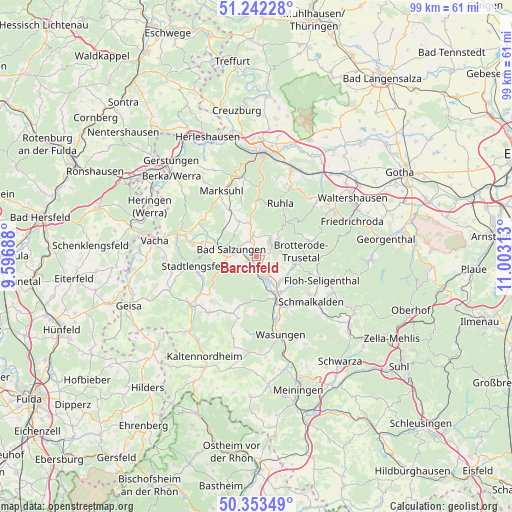
Barchfeld GPS coordinates[2]
50° 48' 0" North, 10° 18' 0" East
| Map corner | latitude | longitude |
|---|---|---|
| Upper-left | 51.24228°, | 9.59688° |
| Center: | 50.8°, | 10.3° |
| Lower-right: | 50.35349°, | 11.00313° |
| Map W x H: | 98.8×98.8 km | = 61.4×61.4mi |
| max Lat: | 55.01917° ⇑45.9% North |
| Barchfeld: | 50.8° |
| min Lat: | ⇓54.1% South 47.40724° |
| min Long | Barchfeld | max Long |
| 5.92978° | 10.3° | 14.98853° |
| W 55.3%⇐ | ⇒44.7% E |
Elevation
Elevation of Barchfeld is 250 m = 820 ft, and this is 0.90000000000001 m = 3 ft above average elevation for this country.
| Max E: |
1256 m = 4121 ft | 46.4% |
| Barchfeld | 250 m 820 ft | |
| Avg. | 249.1 m = 817 ft | |
Min E: |
-5 m = -16 ft | 53.6% |
See also: Germany elevation on elevation.city.
Geographical zone
Barchfeld is located in North temperate zone (between Tropic of Cancer and the Arctic Circle). Distance of this North polar circle is 1752.7 km =1089.1 mi to North.| Distance of | km | miles | from Barchfeld |
|---|---|---|---|
| North Pole | 4358.6 | 2708.3 | to North |
| Arctic Circle | 1752.7 | 1089.1 | to North |
| Tropic Cancer | 3042.5 | 1890.5 | to South |
| Equator | 5648.4 | 3509.8 | to South |


Nearby cities:
15 places around Barchfeld: (largest is in red/bold)
• Bad Liebenstein
4 km =2.5 mi,  64°
64°
• Bad Salzungen
4.7 km =2.9 mi,  288°
288°
• Breitungen
4.5 km =2.8 mi,  154°
154°
• Brotterode
10.5 km =6.5 mi,  75°
75°
• Ettenhausen
10.1 km =6.3 mi,  331°
331°
• Fambach
8.8 km =5.5 mi, 147°
• Immelborn
1.8 km =1.1 mi,  240°
240°
• Leimbach
7.3 km =4.5 mi,  284°
284°
• Rosa
10.4 km =6.5 mi,  199°
199°
• Schweina
3.8 km =2.4 mi,  43°
43°
• Steinbach
5.8 km =3.6 mi,  50°
50°
• Tiefenort
10.4 km =6.5 mi, 294°
• Trusetal
8.4 km =5.2 mi,  102°
102°
• Weilar
11.2 km =7 mi,  250°
250°
• Wernshausen
9.2 km =5.7 mi,  157°
157°
Sources, notices
• [Note1] Compared only with cities in Germany existing in our database
• [Src1] Map data: © OpenStreetMap contributors (CC-BY-SA)
• [Src2] Other city data from geonames.org with taken over terms of usage.
• [Src3] Geographical zone / Annual Mean Temperature by Robert A. Rohde @ Wikipedia
