Steinbach geodata
Steinbach (Thuringia) is a populated place; located in Germany in Europe/Berlin (GMT+2) time zone. With population of 1,345 people, there are 6191 cities with bigger population in this country. Compared to other cities in Germany, 54.8% of cities are located further ↓South; 56.6% of cities are located further ←West and 74.6% of cities have lower elevation than Steinbach. Note1


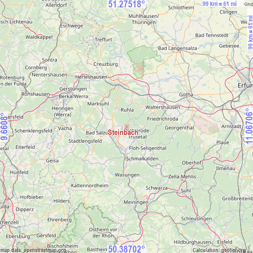
Steinbach GPS coordinates[2]
50° 49' 59.556" North, 10° 21' 50.148" East
| Map corner | latitude | longitude |
|---|---|---|
| Upper-left | 51.27518°, | 9.6608° |
| Center: | 50.83321°, | 10.36393° |
| Lower-right: | 50.38702°, | 11.06706° |
| Map W x H: | 98.8×98.8 km | = 61.4×61.4mi |
| max Lat: | 55.01917° ⇑45.2% North |
| Steinbach: | 50.83321° |
| min Lat: | ⇓54.8% South 47.40724° |
| min Long | Steinbach | max Long |
| 5.92978° | 10.36393° | 14.98853° |
| W 56.6%⇐ | ⇒43.4% E |
Elevation
Elevation of Steinbach is 394 m = 1293 ft, and this is 144.9 m = 475 ft above average elevation for this country.
| Max E: |
1256 m = 4121 ft | 25.4% |
| Steinbach | 394 m 1293 ft | |
| Avg. | 249.1 m = 817 ft | |
Min E: |
-5 m = -16 ft | 74.6% |
See also: Germany elevation on elevation.city.
Geographical zone
Steinbach is located in North temperate zone (between Tropic of Cancer and the Arctic Circle). Distance of this North polar circle is 1749.1 km =1086.8 mi to North.| Distance of | km | miles | from Steinbach |
|---|---|---|---|
| North Pole | 4354.9 | 2706 | to North |
| Arctic Circle | 1749.1 | 1086.8 | to North |
| Tropic Cancer | 3046.2 | 1892.8 | to South |
| Equator | 5652.1 | 3512.1 | to South |


Nearby cities:
15 places around Steinbach: (largest is in red/bold)
• Bad Liebenstein
2.1 km =1.3 mi,  204°
204°
• Bad Salzungen
9.2 km =5.7 mi,  256°
256°
• Barchfeld
5.8 km =3.6 mi,  230°
230°
• Breitungen
8.2 km =5.1 mi, 198°
• Brotterode
5.7 km =3.5 mi,  100°
100°
• Ettenhausen
10.6 km =6.6 mi,  299°
299°
• Fambach
11.1 km =6.9 mi,  179°
179°
• Immelborn
7.6 km =4.7 mi, 232°
• Pappenheim
8.8 km =5.5 mi,  117°
117°
• Ruhla
6.6 km =4.1 mi,  1°
1°
• Schweina
2 km =1.2 mi,  243°
243°
• Seebach
10 km =6.2 mi,  21°
21°
• Tabarz
11.7 km =7.3 mi,  66°
66°
• Thal
9.5 km =5.9 mi,  11°
11°
• Trusetal
6.7 km =4.2 mi,  146°
146°
Sources, notices
• [Note1] Compared only with cities in Germany existing in our database
• [Src1] Map data: © OpenStreetMap contributors (CC-BY-SA)
• [Src2] Other city data from geonames.org with taken over terms of usage.
• [Src3] Geographical zone / Annual Mean Temperature by Robert A. Rohde @ Wikipedia
