Bad Liebenstein geodata
Bad Liebenstein (Thuringia) is a populated place; located in Germany in Europe/Berlin (GMT+2) time zone. With population of 4,094 people, there are 3238 cities with bigger population in this country. Compared to other cities in Germany, 54.4% of cities are located further ↓South; 56.4% of cities are located further ←West and 65.7% of cities have lower elevation than Bad Liebenstein. Note1


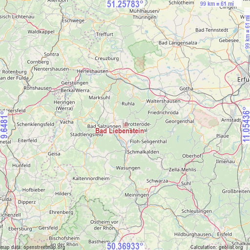
Bad Liebenstein GPS coordinates[2]
50° 48' 56.484" North, 10° 21' 4.428" East
| Map corner | latitude | longitude |
|---|---|---|
| Upper-left | 51.25783°, | 9.6481° |
| Center: | 50.81569°, | 10.35123° |
| Lower-right: | 50.36933°, | 11.05436° |
| Map W x H: | 98.8×98.8 km | = 61.4×61.4mi |
| max Lat: | 55.01917° ⇑45.6% North |
| Bad Liebenstein: | 50.81569° |
| min Lat: | ⇓54.4% South 47.40724° |
| min Long | Bad Liebenstein | max Long |
| 5.92978° | 10.35123° | 14.98853° |
| W 56.4%⇐ | ⇒43.6% E |
Elevation
Elevation of Bad Liebenstein is 326 m = 1070 ft, and this is 76.9 m = 252 ft above average elevation for this country.
| Max E: |
1256 m = 4121 ft | 34.3% |
| Bad Liebenstein | 326 m 1070 ft | |
| Avg. | 249.1 m = 817 ft | |
Min E: |
-5 m = -16 ft | 65.7% |
See also: Germany elevation on elevation.city.
Geographical zone
Bad Liebenstein is located in North temperate zone (between Tropic of Cancer and the Arctic Circle). Distance of this North polar circle is 1751 km =1088 mi to North.| Distance of | km | miles | from Bad Liebenstein |
|---|---|---|---|
| North Pole | 4356.9 | 2707.3 | to North |
| Arctic Circle | 1751 | 1088 | to North |
| Tropic Cancer | 3044.3 | 1891.6 | to South |
| Equator | 5650.2 | 3510.9 | to South |


Nearby cities:
15 places around Bad Liebenstein: (largest is in red/bold)
• Bad Salzungen
8.1 km =5 mi,  268°
268°
• Barchfeld
4 km =2.5 mi,  244°
244°
• Breitungen
6 km =3.7 mi,  196°
196°
• Brotterode
6.6 km =4.1 mi,  81°
81°
• Ettenhausen
11 km =6.8 mi,  310°
310°
• Fambach
9.2 km =5.7 mi,  173°
173°
• Immelborn
5.8 km =3.6 mi, 243°
• Leimbach
10.6 km =6.6 mi, 270°
• Pappenheim
9 km =5.6 mi,  103°
103°
• Ruhla
8.7 km =5.4 mi,  6°
6°
• Schweina
1.4 km =0.9 mi,  317°
317°
• Steinbach
2.1 km =1.3 mi,  24°
24°
• Thal
11.6 km =7.2 mi, 14°
• Trusetal
5.8 km =3.6 mi,  128°
128°
• Wernshausen
10.2 km =6.3 mi,  180°
180°
Sources, notices
• [Note1] Compared only with cities in Germany existing in our database
• [Src1] Map data: © OpenStreetMap contributors (CC-BY-SA)
• [Src2] Other city data from geonames.org with taken over terms of usage.
• [Src3] Geographical zone / Annual Mean Temperature by Robert A. Rohde @ Wikipedia
