Hartenstein geodata
Hartenstein (Bavaria) is a seat of a fourth-order administrative division; located in Germany in Europe/Berlin (GMT+2) time zone. With population of 1,534 people, there are 5813 cities with bigger population in this country. Compared to other cities in Germany, 73.8% of cities are located further ↑North; 74.5% of cities are located further ←West and 82.7% of cities have lower elevation than Hartenstein. Note1
Administrative division(s):
- Level 1: Bavaria
- Level 2: Regierungsbezirk Mittelfranken
- Level 3: Nürnberger Land
- Level 4: Hartenstein


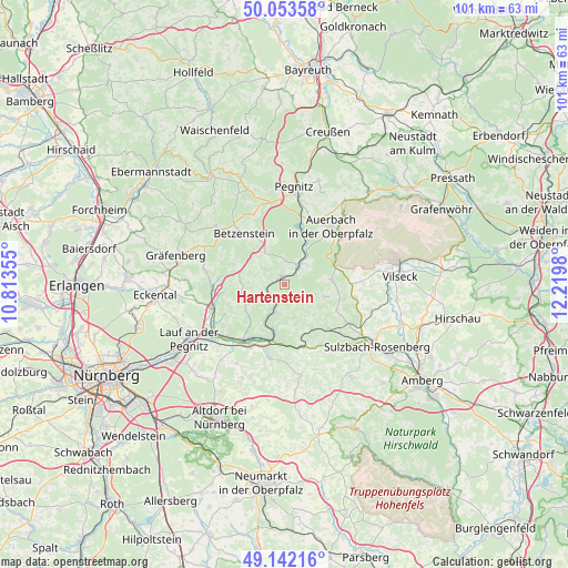
Hartenstein GPS coordinates[2]
49° 36' 0" North, 11° 31' 0.012" East
| Map corner | latitude | longitude |
|---|---|---|
| Upper-left | 50.05358°, | 10.81355° |
| Center: | 49.6°, | 11.51667° |
| Lower-right: | 49.14216°, | 12.2198° |
| Map W x H: | 101.3×101.3 km | = 62.9×62.9mi |
| max Lat: | 55.01917° ⇑73.8% North |
| Hartenstein: | 49.6° |
| min Lat: | ⇓26.2% South 47.40724° |
| min Long | Hartenstein | max Long |
| 5.92978° | 11.51667° | 14.98853° |
| W 74.5%⇐ | ⇒25.5% E |
Elevation
Elevation of Hartenstein is 451 m = 1480 ft, and this is 201.9 m = 662 ft above average elevation for this country.
| Max E: |
1256 m = 4121 ft | 17.3% |
| Hartenstein | 451 m 1480 ft | |
| Avg. | 249.1 m = 817 ft | |
Min E: |
-5 m = -16 ft | 82.7% |
See also: Germany elevation on elevation.city.
Geographical zone
Hartenstein is located in North temperate zone (between Tropic of Cancer and the Arctic Circle). Distance of this North polar circle is 1886.2 km =1172 mi to North.| Distance of | km | miles | from Hartenstein |
|---|---|---|---|
| North Pole | 4492.1 | 2791.3 | to North |
| Arctic Circle | 1886.2 | 1172 | to North |
| Tropic Cancer | 2909.1 | 1807.6 | to South |
| Equator | 5515 | 3426.9 | to South |


Nearby cities:
15 places around Hartenstein: (largest is in red/bold)
• Auerbach
13.2 km =8.2 mi,  39°
39°
• Edelsfeld
13.2 km =8.2 mi,  101°
101°
• Etzelwang
9.5 km =5.9 mi,  148°
148°
• Happurg
12.3 km =7.6 mi,  195°
195°
• Hersbruck
11.7 km =7.3 mi,  211°
211°
• Hirschbach
5.7 km =3.5 mi,  167°
167°
• Kirchensittenbach
8.4 km =5.2 mi,  234°
234°
• Königstein
8.3 km =5.2 mi,  83°
83°
• Neuhaus an der Pegnitz
4 km =2.5 mi, 38°
• Pommelsbrunn
10.6 km =6.6 mi,  182°
182°
• Schnaittach
13.3 km =8.3 mi,  250°
250°
• Simmelsdorf
12.8 km =8 mi,  268°
268°
• Velden
1.6 km =1 mi,  342°
342°
• Vorra
5 km =3.1 mi, 198°
• Weigendorf
12 km =7.5 mi,  161°
161°
Sources, notices
• [Note1] Compared only with cities in Germany existing in our database
• [Src1] Map data: © OpenStreetMap contributors (CC-BY-SA)
• [Src2] Other city data from geonames.org with taken over terms of usage.
• [Src3] Geographical zone / Annual Mean Temperature by Robert A. Rohde @ Wikipedia
