Brunnen geodata
Brunnen (Bavaria) is a seat of a fourth-order administrative division; located in Germany in Europe/Berlin (GMT+2) time zone. In our database, there are 11009 cities with bigger population. Compared to other cities in Germany, 87.4% of cities are located further ↑North; 71.4% of cities are located further ←West and 75.1% of cities have lower elevation than Brunnen. Note1
Administrative division(s):
- Level 1: Bavaria
- Level 2: Upper Bavaria
- Level 3: Landkreis Neuburg-Schrobenhausen
- Level 4: Brunnen


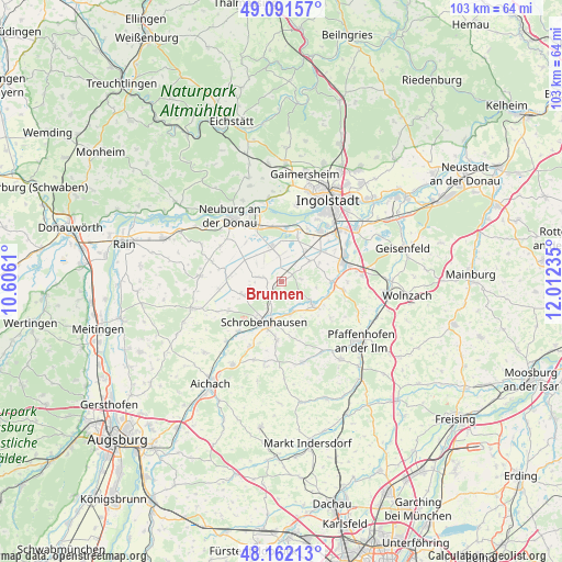
Brunnen GPS coordinates[2]
48° 37' 44.364" North, 11° 18' 33.192" East
| Map corner | latitude | longitude |
|---|---|---|
| Upper-left | 49.09157°, | 10.6061° |
| Center: | 48.62899°, | 11.30922° |
| Lower-right: | 48.16213°, | 12.01235° |
| Map W x H: | 103.3×103.3 km | = 64.2×64.2mi |
| max Lat: | 55.01917° ⇑87.4% North |
| Brunnen: | 48.62899° |
| min Lat: | ⇓12.6% South 47.40724° |
| min Long | Brunnen | max Long |
| 5.92978° | 11.30922° | 14.98853° |
| W 71.4%⇐ | ⇒28.6% E |
Elevation
Elevation of Brunnen is 398 m = 1306 ft, and this is 148.9 m = 489 ft above average elevation for this country.
| Max E: |
1256 m = 4121 ft | 24.9% |
| Brunnen | 398 m 1306 ft | |
| Avg. | 249.1 m = 817 ft | |
Min E: |
-5 m = -16 ft | 75.1% |
See also: Germany elevation on elevation.city.
Geographical zone
Brunnen is located in North temperate zone (between Tropic of Cancer and the Arctic Circle). Distance of this North polar circle is 1994.1 km =1239.1 mi to North.| Distance of | km | miles | from Brunnen |
|---|---|---|---|
| North Pole | 4600 | 2858.3 | to North |
| Arctic Circle | 1994.1 | 1239.1 | to North |
| Tropic Cancer | 2801.1 | 1740.5 | to South |
| Equator | 5407 | 3359.8 | to South |


Nearby cities:
15 places around Brunnen: (largest is in red/bold)
• Aresing
10.7 km =6.6 mi,  183°
183°
• Baar-Ebenhausen
12.7 km =7.9 mi,  68°
68°
• Berg im Gau
4.4 km =2.7 mi,  276°
276°
• Bergheim
15.1 km =9.4 mi,  345°
345°
• Gachenbach
15.4 km =9.6 mi,  201°
201°
• Karlshuld
6.1 km =3.8 mi,  343°
343°
• Karlskron
9.9 km =6.2 mi,  52°
52°
• Langenmosen
7.4 km =4.6 mi,  250°
250°
• Neuburg an der Donau
14.6 km =9.1 mi,  321°
321°
• Pörnbach
11.7 km =7.3 mi,  96°
96°
• Reichertshofen
12 km =7.5 mi, 74°
• Rohrenfels
12.9 km =8 mi,  299°
299°
• Schrobenhausen
8.4 km =5.2 mi,  205°
205°
• Waidhofen
6.1 km =3.8 mi,  161°
161°
• Weichering
9.8 km =6.1 mi,  5°
5°
Sources, notices
• [Note1] Compared only with cities in Germany existing in our database
• [Src1] Map data: © OpenStreetMap contributors (CC-BY-SA)
• [Src2] Other city data from geonames.org with taken over terms of usage.
• [Src3] Geographical zone / Annual Mean Temperature by Robert A. Rohde @ Wikipedia
