Merouana geodata
Merouana (Batna) is a populated place; located in Algeria in Africa/Algiers (GMT+1) time zone. With population of 47,646 people, there are 105 cities with bigger population in this country. Compared to other cities in Algeria, 64% of cities are located further ↑North; 79.1% of cities are located further ←West and 88.4% of cities have lower elevation than Merouana. Note1


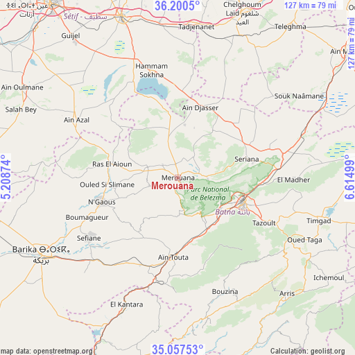
Merouana GPS coordinates[2]
35° 37' 51.816" North, 5° 54' 42.696" East
| Map corner | latitude | longitude |
|---|---|---|
| Upper-left | 36.2005°, | 5.20874° |
| Center: | 35.63106°, | 5.91186° |
| Lower-right: | 35.05753°, | 6.61499° |
| Map W x H: | 127.1×127.1 km | = 79×79mi |
| max Lat: | 36.92917° ⇑64% North |
| Merouana: | 35.63106° |
| min Lat: | ⇓36% South 22.785° |
| min Long | Merouana | max Long |
| -8.14743° | 5.91186° | 8.46667° |
| W 79.1%⇐ | ⇒20.9% E |
Elevation
Elevation of Merouana is 992 m = 3255 ft, and this is 553.5 m = 1816 ft above average elevation for this country.
| Max E: |
1392 m = 4567 ft | 11.6% |
| Merouana | 992 m 3255 ft | |
| Avg. | 438.5 m = 1439 ft | |
Min E: |
5 m = 16 ft | 88.4% |
See also: Merouana elevation on elevation.city.
Geographical zone
Merouana is located in North temperate zone (between Tropic of Cancer and the Arctic Circle). Distance of this Northern Tropic circle is 1355.9 km =842.5 mi to South.| Distance of | km | miles | from Merouana |
|---|---|---|---|
| North Pole | 6045.3 | 3756.4 | to North |
| Arctic Circle | 3439.4 | 2137.1 | to North |
| Tropic Cancer | 1355.9 | 842.5 | to South |
| Equator | 3961.8 | 2461.7 | to South |


Nearby cities:
15 places around Merouana: (largest is in red/bold)
• Arris
57.2 km =35.5 mi,  136°
136°
• Aïn Arnat
82 km =51 mi,  318°
318°
• Aïn Kercha
77.8 km =48.3 mi,  65°
65°
• Aïn Touta
28.3 km =17.6 mi,  182°
182°
• Barika
56.3 km =35 mi,  241°
241°
• Batna
25.1 km =15.6 mi,  109°
109°
• Boumagueur
35.4 km =22 mi,  246°
246°
• Chelghoum el Aïd
63.4 km =39.4 mi,  21°
21°
• El Eulma
61.4 km =38.2 mi,  341°
341°
• Râs el Aïoun
24.5 km =15.2 mi,  281°
281°
• Râs el Oued
86.7 km =53.9 mi,  293°
293°
• Salah Bey
61.3 km =38.1 mi, 293°
• Sétif
76.7 km =47.7 mi, 324°
• Tazoult-Lambese
35.7 km =22.2 mi,  117°
117°
• Telerghma
67.1 km =41.7 mi,  36°
36°
Sources, notices
• [Note1] Compared only with cities in Algeria existing in our database
• [Src1] Map data: © OpenStreetMap contributors (CC-BY-SA)
• [Src2] Other city data from geonames.org with taken over terms of usage.
• [Src3] Geographical zone / Annual Mean Temperature by Robert A. Rohde @ Wikipedia
