Batna geodata
Batna is a seat of a first-order administrative division; located in Algeria in Africa/Algiers (GMT+1) time zone. With population of 280,798 people, there are 7 cities with bigger population in this country. Compared to other cities in Algeria, 65.5% of cities are located further ↑North; 82.6% of cities are located further ←West and 91.5% of cities have lower elevation than Batna. Note1


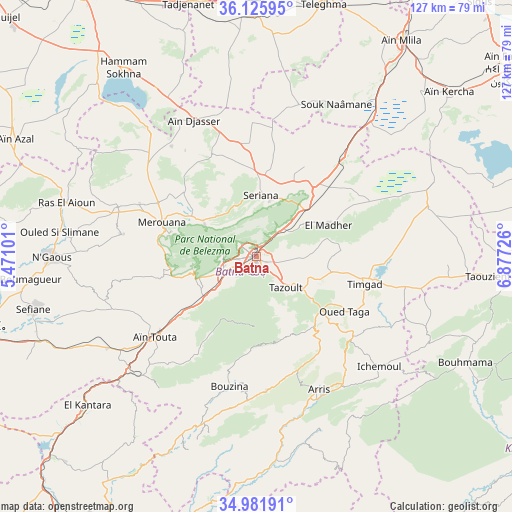
Batna GPS coordinates[2]
35° 33' 21.492" North, 6° 10' 26.904" East
| Map corner | latitude | longitude |
|---|---|---|
| Upper-left | 36.12595°, | 5.47101° |
| Center: | 35.55597°, | 6.17414° |
| Lower-right: | 34.98191°, | 6.87726° |
| Map W x H: | 127.2×127.2 km | = 79×79mi |
| max Lat: | 36.92917° ⇑65.5% North |
| Batna: | 35.55597° |
| min Lat: | ⇓34.5% South 22.785° |
| min Long | Batna | max Long |
| -8.14743° | 6.17414° | 8.46667° |
| W 82.6%⇐ | ⇒17.4% E |
Elevation
Elevation of Batna is 1037 m = 3402 ft, and this is 598.5 m = 1964 ft above average elevation for this country.
| Max E: |
1392 m = 4567 ft | 8.5% |
| Batna | 1037 m 3402 ft | |
| Avg. | 438.5 m = 1439 ft | |
Min E: |
5 m = 16 ft | 91.5% |
See also: Batna elevation on elevation.city.
Geographical zone
Batna is located in North temperate zone (between Tropic of Cancer and the Arctic Circle). Distance of this Northern Tropic circle is 1347.5 km =837.3 mi to South.| Distance of | km | miles | from Batna |
|---|---|---|---|
| North Pole | 6053.6 | 3761.5 | to North |
| Arctic Circle | 3447.7 | 2142.3 | to North |
| Tropic Cancer | 1347.5 | 837.3 | to South |
| Equator | 3953.5 | 2456.6 | to South |


Nearby cities:
15 places around Batna: (largest is in red/bold)
• Arris
36.6 km =22.7 mi,  154°
154°
• Aïn Fakroun
78.2 km =48.6 mi,  53°
53°
• Aïn Kercha
62.4 km =38.8 mi, 48°
• Aïn Smara
84.4 km =52.4 mi,  20°
20°
• Aïn Touta
31.8 km =19.8 mi,  231°
231°
• Barika
75.5 km =46.9 mi,  255°
255°
• Biskra
88.3 km =54.9 mi,  207°
207°
• Boumagueur
56.5 km =35.1 mi, 264°
• Chelghoum el Aïd
67.5 km =41.9 mi,  359°
359°
• El Eulma
79.4 km =49.3 mi,  326°
326°
• Merouana
25.1 km =15.6 mi,  289°
289°
• Râs el Aïoun
49.6 km =30.8 mi, 285°
• Salah Bey
86.4 km =53.7 mi, 292°
• Tazoult-Lambese
11.4 km =7.1 mi,  136°
136°
• Telerghma
64.4 km =40 mi,  14°
14°
Sources, notices
• [Note1] Compared only with cities in Algeria existing in our database
• [Src1] Map data: © OpenStreetMap contributors (CC-BY-SA)
• [Src2] Other city data from geonames.org with taken over terms of usage.
• [Src3] Geographical zone / Annual Mean Temperature by Robert A. Rohde @ Wikipedia
