El Eulma geodata
El Eulma (Sétif) is a populated place; located in Algeria in Africa/Algiers (GMT+1) time zone. With population of 128,351 people, there are 31 cities with bigger population in this country. Compared to other cities in Algeria, 53.5% of cities are located further ↓South; 77.1% of cities are located further ←West and 87.6% of cities have lower elevation than El Eulma. Note1


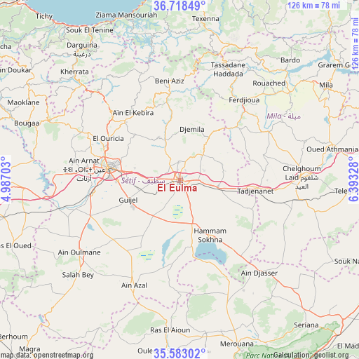
El Eulma GPS coordinates[2]
36° 9' 10.116" North, 5° 41' 24.576" East
| Map corner | latitude | longitude |
|---|---|---|
| Upper-left | 36.71849°, | 4.98703° |
| Center: | 36.15281°, | 5.69016° |
| Lower-right: | 35.58302°, | 6.39328° |
| Map W x H: | 126.3×126.3 km | = 78.5×78.5mi |
| max Lat: | 36.92917° ⇑46.5% North |
| El Eulma: | 36.15281° |
| min Lat: | ⇓53.5% South 22.785° |
| min Long | El Eulma | max Long |
| -8.14743° | 5.69016° | 8.46667° |
| W 77.1%⇐ | ⇒22.9% E |
Elevation
Elevation of El Eulma is 959 m = 3146 ft, and this is 520.5 m = 1708 ft above average elevation for this country.
| Max E: |
1392 m = 4567 ft | 12.4% |
| El Eulma | 959 m 3146 ft | |
| Avg. | 438.5 m = 1439 ft | |
Min E: |
5 m = 16 ft | 87.6% |
See also: El Eulma elevation on elevation.city.
Geographical zone
El Eulma is located in North temperate zone (between Tropic of Cancer and the Arctic Circle). Distance of this Northern Tropic circle is 1413.9 km =878.6 mi to South.| Distance of | km | miles | from El Eulma |
|---|---|---|---|
| North Pole | 5987.2 | 3720.3 | to North |
| Arctic Circle | 3381.4 | 2101.1 | to North |
| Tropic Cancer | 1413.9 | 878.6 | to South |
| Equator | 4019.8 | 2497.8 | to South |


Nearby cities:
15 places around El Eulma: (largest is in red/bold)
• Aïn Arnat
34 km =21.1 mi,  276°
276°
• Aïn Smara
73.9 km =45.9 mi,  80°
80°
• BABOR - VILLE
39.8 km =24.7 mi,  340°
340°
• Bougaa
57.6 km =35.8 mi,  290°
290°
• Boumagueur
73.1 km =45.4 mi,  189°
189°
• Chelghoum el Aïd
42.8 km =26.6 mi,  88°
88°
• Merouana
61.4 km =38.2 mi,  161°
161°
• Mila
61.2 km =38 mi,  57°
57°
• Rouached
46.3 km =28.8 mi,  42°
42°
• Râs el Aïoun
53.4 km =33.2 mi,  184°
184°
• Râs el Oued
63.6 km =39.5 mi,  248°
248°
• Salah Bey
48.9 km =30.4 mi,  227°
227°
• Sidi Mérouane
65.5 km =40.7 mi,  51°
51°
• Sétif
25.2 km =15.7 mi, 279°
• Telerghma
59.8 km =37.2 mi, 93°
Sources, notices
• [Note1] Compared only with cities in Algeria existing in our database
• [Src1] Map data: © OpenStreetMap contributors (CC-BY-SA)
• [Src2] Other city data from geonames.org with taken over terms of usage.
• [Src3] Geographical zone / Annual Mean Temperature by Robert A. Rohde @ Wikipedia
