Meskiana geodata
Meskiana (Oum el Bouaghi) is a populated place; located in Algeria in Africa/Algiers (GMT+1) time zone. With population of 30,071 people, there are 173 cities with bigger population in this country. Compared to other cities in Algeria, 64.3% of cities are located further ↑North; 94.6% of cities are located further ←West and 77.9% of cities have lower elevation than Meskiana. Note1


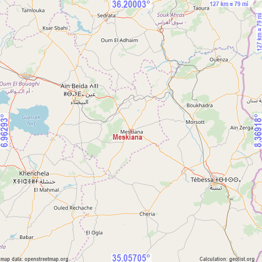
Meskiana GPS coordinates[2]
35° 37' 50.088" North, 7° 39' 57.816" East
| Map corner | latitude | longitude |
|---|---|---|
| Upper-left | 36.20003°, | 6.96293° |
| Center: | 35.63058°, | 7.66606° |
| Lower-right: | 35.05705°, | 8.36918° |
| Map W x H: | 127.1×127.1 km | = 79×79mi |
| max Lat: | 36.92917° ⇑64.3% North |
| Meskiana: | 35.63058° |
| min Lat: | ⇓35.7% South 22.785° |
| min Long | Meskiana | max Long |
| -8.14743° | 7.66606° | 8.46667° |
| W 94.6%⇐ | ⇒5.4% E |
Elevation
Elevation of Meskiana is 850 m = 2789 ft, and this is 411.5 m = 1350 ft above average elevation for this country.
| Max E: |
1392 m = 4567 ft | 22.1% |
| Meskiana | 850 m 2789 ft | |
| Avg. | 438.5 m = 1439 ft | |
Min E: |
5 m = 16 ft | 77.9% |
See also: Algeria elevation on elevation.city.
Geographical zone
Meskiana is located in North temperate zone (between Tropic of Cancer and the Arctic Circle). Distance of this Northern Tropic circle is 1355.8 km =842.5 mi to South.| Distance of | km | miles | from Meskiana |
|---|---|---|---|
| North Pole | 6045.3 | 3756.4 | to North |
| Arctic Circle | 3439.4 | 2137.1 | to North |
| Tropic Cancer | 1355.8 | 842.5 | to South |
| Equator | 3961.7 | 2461.7 | to South |


Nearby cities:
15 places around Meskiana: (largest is in red/bold)
• Aïn Beïda
30.8 km =19.1 mi,  306°
306°
• Aïn Fakroun
80.9 km =50.3 mi,  297°
297°
• Aïn Kercha
93.5 km =58.1 mi,  290°
290°
• Boumahra Ahmed
93 km =57.8 mi,  351°
351°
• Cheria
40.5 km =25.2 mi,  168°
168°
• El Aouinet
33 km =20.5 mi,  37°
37°
• Guelma
94.9 km =59 mi, 346°
• Hammamet
32.8 km =20.4 mi,  128°
128°
• Héliopolis
99.1 km =61.6 mi, 348°
• Khenchela
52 km =32.3 mi,  245°
245°
• Oum el Bouaghi
56.8 km =35.3 mi, 298°
• Sedrata
56.7 km =35.2 mi, 347°
• Souk Ahras
77.3 km =48 mi,  19°
19°
• Tébessa
48.5 km =30.1 mi,  121°
121°
• ’Aïn Abid
93.3 km =58 mi,  315°
315°
Sources, notices
• [Note1] Compared only with cities in Algeria existing in our database
• [Src1] Map data: © OpenStreetMap contributors (CC-BY-SA)
• [Src2] Other city data from geonames.org with taken over terms of usage.
• [Src3] Geographical zone / Annual Mean Temperature by Robert A. Rohde @ Wikipedia
