Saïda geodata
Saïda (Saida) is a seat of a first-order administrative division; located in Algeria in Africa/Algiers (GMT+1) time zone. With population of 127,497 people, there are 32 cities with bigger population in this country. Compared to other cities in Algeria, 82.6% of cities are located further ↑North; 85.3% of cities are located further →East and 76.7% of cities have lower elevation than Saïda. Note1


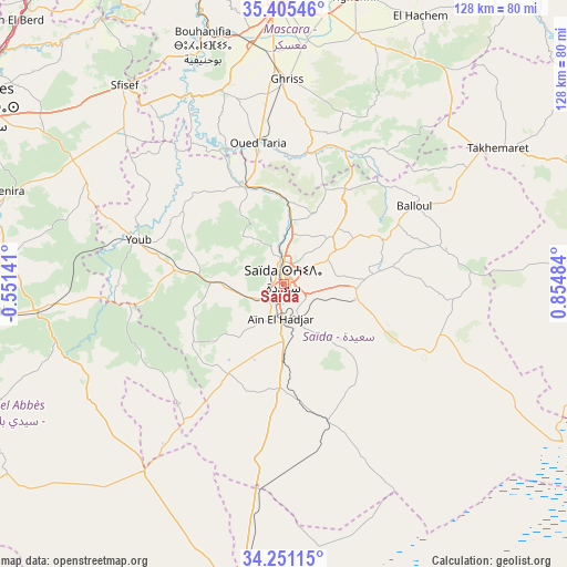
Saïda GPS coordinates[2]
34° 49' 49.188" North, 0° 9' 6.156" East
| Map corner | latitude | longitude |
|---|---|---|
| Upper-left | 35.40546°, | -0.55141° |
| Center: | 34.83033°, | 0.15171° |
| Lower-right: | 34.25115°, | 0.85484° |
| Map W x H: | 128.3×128.3 km | = 79.7×79.7mi |
| max Lat: | 36.92917° ⇑82.6% North |
| Saïda: | 34.83033° |
| min Lat: | ⇓17.4% South 22.785° |
| min Long | Saïda | max Long |
| -8.14743° | 0.15171° | 8.46667° |
| W 14.7%⇐ | ⇒85.3% E |
Elevation
Elevation of Saïda is 840 m = 2756 ft, and this is 401.5 m = 1317 ft above average elevation for this country.
| Max E: |
1392 m = 4567 ft | 23.3% |
| Saïda | 840 m 2756 ft | |
| Avg. | 438.5 m = 1439 ft | |
Min E: |
5 m = 16 ft | 76.7% |
See also: Saïda elevation on elevation.city.
Geographical zone
Saïda is located in North temperate zone (between Tropic of Cancer and the Arctic Circle). Distance of this Northern Tropic circle is 1266.9 km =787.2 mi to South.| Distance of | km | miles | from Saïda |
|---|---|---|---|
| North Pole | 6134.3 | 3811.7 | to North |
| Arctic Circle | 3528.4 | 2192.4 | to North |
| Tropic Cancer | 1266.9 | 787.2 | to South |
| Equator | 3872.8 | 2406.4 | to South |


Nearby cities:
15 places around Saïda: (largest is in red/bold)
• Bou Hanifia el Hamamat
56.9 km =35.4 mi,  341°
341°
• Djebilet Rosfa
62.5 km =38.8 mi,  86°
86°
• Frenda
85.9 km =53.4 mi,  72°
72°
• Mascara
63 km =39.1 mi,  359°
359°
• Oued el Abtal
84.9 km =52.8 mi,  35°
35°
• Ouled Mimoun
108.5 km =67.4 mi,  274°
274°
• Relizane
107.3 km =66.7 mi,  19°
19°
• Rouachdia
110.9 km =68.9 mi,  28°
28°
• Sfizef
57.6 km =35.8 mi,  321°
321°
• Sidi Bel Abbès
81.7 km =50.8 mi,  299°
299°
• Sidi ech Chahmi
110.6 km =68.7 mi,  326°
326°
• Sig
83.7 km =52 mi, 337°
• Smala
112.7 km =70 mi, 29°
• ’Aïn el Berd
84.7 km =52.6 mi,  314°
314°
• ’Aïn el Hadjar
8 km =5 mi,  184°
184°
Sources, notices
• [Note1] Compared only with cities in Algeria existing in our database
• [Src1] Map data: © OpenStreetMap contributors (CC-BY-SA)
• [Src2] Other city data from geonames.org with taken over terms of usage.
• [Src3] Geographical zone / Annual Mean Temperature by Robert A. Rohde @ Wikipedia
