’Aïn el Hadjar geodata
’Aïn el Hadjar (Saida) is a populated place; located in Algeria in Africa/Algiers (GMT+1) time zone. With population of 12,996 people, there are 247 cities with bigger population in this country. Compared to other cities in Algeria, 82.9% of cities are located further ↑North; 85.7% of cities are located further →East and 90.7% of cities have lower elevation than ’Aïn el Hadjar. Note1


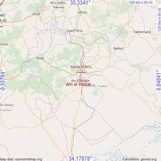
’Aïn el Hadjar GPS coordinates[2]
34° 45' 30.456" North, 0° 8' 43.008" East
| Map corner | latitude | longitude |
|---|---|---|
| Upper-left | 35.3341°, | -0.55784° |
| Center: | 34.75846°, | 0.14528° |
| Lower-right: | 34.17878°, | 0.84841° |
| Map W x H: | 128.5×128.5 km | = 79.8×79.8mi |
| max Lat: | 36.92917° ⇑82.9% North |
| ’Aïn el Hadjar: | 34.75846° |
| min Lat: | ⇓17.1% South 22.785° |
| min Long | ’Aïn el Hadj | max Long |
| -8.14743° | 0.14528° | 8.46667° |
| W 14.3%⇐ | ⇒85.7% E |
Elevation
Elevation of ’Aïn el Hadjar is 1024 m = 3360 ft, and this is 585.5 m = 1921 ft above average elevation for this country.
| Max E: |
1392 m = 4567 ft | 9.3% |
| ’Aïn el Hadjar | 1024 m 3360 ft | |
| Avg. | 438.5 m = 1439 ft | |
Min E: |
5 m = 16 ft | 90.7% |
See also: Algeria elevation on elevation.city.
Geographical zone
’Aïn el Hadjar is located in North temperate zone (between Tropic of Cancer and the Arctic Circle). Distance of this Northern Tropic circle is 1258.9 km =782.2 mi to South.| Distance of | km | miles | from ’Aïn el Hadjar |
|---|---|---|---|
| North Pole | 6142.3 | 3816.6 | to North |
| Arctic Circle | 3536.4 | 2197.4 | to North |
| Tropic Cancer | 1258.9 | 782.2 | to South |
| Equator | 3864.8 | 2401.5 | to South |


Nearby cities:
15 places around ’Aïn el Hadjar: (largest is in red/bold)
• Bou Hanifia el Hamamat
64.4 km =40 mi,  343°
343°
• Djebilet Rosfa
64 km =39.8 mi,  79°
79°
• Frenda
89.2 km =55.4 mi,  67°
67°
• Mascara
71 km =44.1 mi,  359°
359°
• Oued el Abtal
91.9 km =57.1 mi,  32°
32°
• Ouled Mimoun
108.8 km =67.6 mi,  278°
278°
• Relizane
115.1 km =71.5 mi,  18°
18°
• Rouachdia
118.3 km =73.5 mi, 26°
• Saïda
8 km =5 mi,  4°
4°
• Sfizef
63.7 km =39.6 mi,  326°
326°
• Sidi Bel Abbès
85.5 km =53.1 mi,  304°
304°
• Sidi Senoussi سيدي سنوسي
116.2 km =72.2 mi, 283°
• Sidi ech Chahmi
117 km =72.7 mi, 328°
• Sig
91 km =56.5 mi, 340°
• ’Aïn el Berd
90.1 km =56 mi,  318°
318°
Sources, notices
• [Note1] Compared only with cities in Algeria existing in our database
• [Src1] Map data: © OpenStreetMap contributors (CC-BY-SA)
• [Src2] Other city data from geonames.org with taken over terms of usage.
• [Src3] Geographical zone / Annual Mean Temperature by Robert A. Rohde @ Wikipedia
