Frenda geodata
Frenda (Tiaret) is a populated place; located in Algeria in Africa/Algiers (GMT+1) time zone. With population of 63,319 people, there are 72 cities with bigger population in this country. Compared to other cities in Algeria, 76.7% of cities are located further ↑North; 79.5% of cities are located further →East and 92.2% of cities have lower elevation than Frenda. Note1


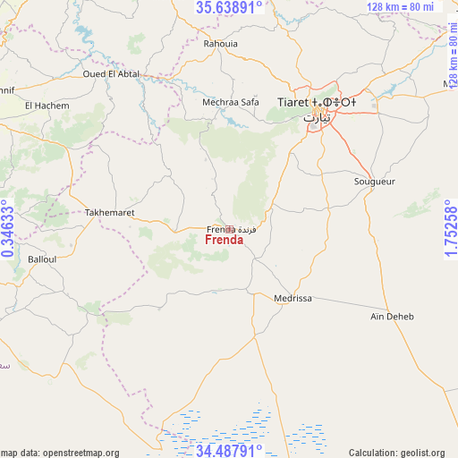
Frenda GPS coordinates[2]
35° 3' 55.584" North, 1° 2' 58.02" East
| Map corner | latitude | longitude |
|---|---|---|
| Upper-left | 35.63891°, | 0.34633° |
| Center: | 35.06544°, | 1.04945° |
| Lower-right: | 34.48791°, | 1.75258° |
| Map W x H: | 128×128 km | = 79.5×79.5mi |
| max Lat: | 36.92917° ⇑76.7% North |
| Frenda: | 35.06544° |
| min Lat: | ⇓23.3% South 22.785° |
| min Long | Frenda | max Long |
| -8.14743° | 1.04945° | 8.46667° |
| W 20.5%⇐ | ⇒79.5% E |
Elevation
Elevation of Frenda is 1058 m = 3471 ft, and this is 619.5 m = 2032 ft above average elevation for this country.
| Max E: |
1392 m = 4567 ft | 7.8% |
| Frenda | 1058 m 3471 ft | |
| Avg. | 438.5 m = 1439 ft | |
Min E: |
5 m = 16 ft | 92.2% |
See also: Frenda elevation on elevation.city.
Geographical zone
Frenda is located in North temperate zone (between Tropic of Cancer and the Arctic Circle). Distance of this Northern Tropic circle is 1293 km =803.4 mi to South.| Distance of | km | miles | from Frenda |
|---|---|---|---|
| North Pole | 6108.2 | 3795.5 | to North |
| Arctic Circle | 3502.3 | 2176.2 | to North |
| Tropic Cancer | 1293 | 803.4 | to South |
| Equator | 3898.9 | 2422.7 | to South |


Nearby cities:
15 places around Frenda: (largest is in red/bold)
• Ammi Moussa
89.4 km =55.6 mi,  3°
3°
• Djebilet Rosfa
29.7 km =18.5 mi,  221°
221°
• Lardjem
88.4 km =54.9 mi,  30°
30°
• Mascara
90.4 km =56.2 mi,  294°
294°
• Mehdia daira de meghila
76 km =47.2 mi,  57°
57°
• Oued el Abtal
54.4 km =33.8 mi,  322°
322°
• Relizane
87.1 km =54.1 mi,  329°
329°
• Rouachdia
77.1 km =47.9 mi,  337°
337°
• Saïda
85.9 km =53.4 mi,  252°
252°
• Smala
77.2 km =48 mi, 339°
• Sougueur
42.8 km =26.6 mi,  71°
71°
• Tiaret
41.8 km =26 mi,  35°
35°
• Zemoura
77.8 km =48.3 mi, 339°
• ’Aïn Deheb
51.7 km =32.1 mi,  118°
118°
• ’Aïn el Hadjar
89.2 km =55.4 mi, 247°
Sources, notices
• [Note1] Compared only with cities in Algeria existing in our database
• [Src1] Map data: © OpenStreetMap contributors (CC-BY-SA)
• [Src2] Other city data from geonames.org with taken over terms of usage.
• [Src3] Geographical zone / Annual Mean Temperature by Robert A. Rohde @ Wikipedia
