M’Sila geodata
M’Sila (M'Sila) is a seat of a first-order administrative division; located in Algeria in Africa/Algiers (GMT+1) time zone. With population of 100,000 people, there are 41 cities with bigger population in this country. Compared to other cities in Algeria, 61.2% of cities are located further ↑North; 65.9% of cities are located further ←West and 58.9% of cities have lower elevation than M’Sila. Note1


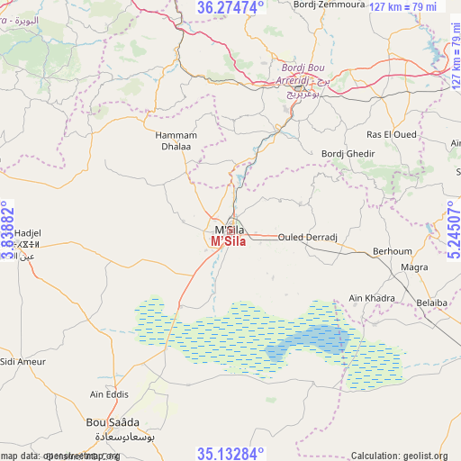
M’Sila GPS coordinates[2]
35° 42' 20.988" North, 4° 32' 30.984" East
| Map corner | latitude | longitude |
|---|---|---|
| Upper-left | 36.27474°, | 3.83882° |
| Center: | 35.70583°, | 4.54194° |
| Lower-right: | 35.13284°, | 5.24507° |
| Map W x H: | 127×127 km | = 78.9×78.9mi |
| max Lat: | 36.92917° ⇑61.2% North |
| M’Sila: | 35.70583° |
| min Lat: | ⇓38.8% South 22.785° |
| min Long | M’Sila | max Long |
| -8.14743° | 4.54194° | 8.46667° |
| W 65.9%⇐ | ⇒34.1% E |
Elevation
Elevation of M’Sila is 477 m = 1565 ft, and this is 38.5 m = 126 ft above average elevation for this country.
| Max E: |
1392 m = 4567 ft | 41.1% |
| M’Sila | 477 m 1565 ft | |
| Avg. | 438.5 m = 1439 ft | |
Min E: |
5 m = 16 ft | 58.9% |
See also: M’Sila elevation on elevation.city.
Geographical zone
M’Sila is located in North temperate zone (between Tropic of Cancer and the Arctic Circle). Distance of this Northern Tropic circle is 1364.2 km =847.7 mi to South.| Distance of | km | miles | from M’Sila |
|---|---|---|---|
| North Pole | 6036.9 | 3751.2 | to North |
| Arctic Circle | 3431.1 | 2132 | to North |
| Tropic Cancer | 1364.2 | 847.7 | to South |
| Equator | 3970.1 | 2466.9 | to South |


Nearby cities:
15 places around M’Sila: (largest is in red/bold)
• Akbou
83.6 km =51.9 mi,  359°
359°
• Barika
82.4 km =51.2 mi,  115°
115°
• Bordj Bou Arreridj
45.4 km =28.2 mi,  25°
25°
• Bordj Ghdir
38.8 km =24.1 mi,  55°
55°
• Bordj Zemoura
69.3 km =43.1 mi,  24°
24°
• Bougaa
85.3 km =53 mi,  35°
35°
• Chorfa
75.8 km =47.1 mi,  345°
345°
• El Achir
40.5 km =25.2 mi,  10°
10°
• Ighram
84.2 km =52.3 mi, 357°
• Mansourah
43.2 km =26.8 mi, 349°
• Melouza
44.2 km =27.5 mi,  313°
313°
• Râs el Oued
51.4 km =31.9 mi, 59°
• Salah Bey
69.5 km =43.2 mi,  76°
76°
• Sidi Aïssa
72.2 km =44.9 mi,  286°
286°
• ‘Aïn el Hadjel
59.8 km =37.2 mi,  266°
266°
Sources, notices
• [Note1] Compared only with cities in Algeria existing in our database
• [Src1] Map data: © OpenStreetMap contributors (CC-BY-SA)
• [Src2] Other city data from geonames.org with taken over terms of usage.
• [Src3] Geographical zone / Annual Mean Temperature by Robert A. Rohde @ Wikipedia
