Melouza geodata
Melouza (Bordj Bou Arréridj) is a populated place; located in Algeria in Africa/Algiers (GMT+1) time zone. With population of 25,701 people, there are 200 cities with bigger population in this country. Compared to other cities in Algeria, 51.2% of cities are located further ↑North; 60.5% of cities are located further ←West and 86% of cities have lower elevation than Melouza. Note1


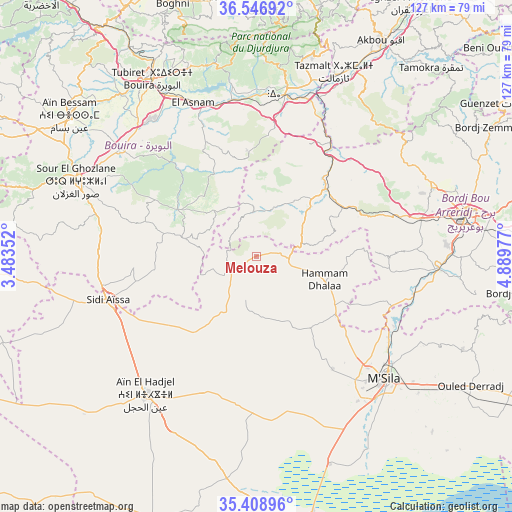
Melouza GPS coordinates[2]
35° 58' 47.964" North, 4° 11' 11.94" East
| Map corner | latitude | longitude |
|---|---|---|
| Upper-left | 36.54692°, | 3.48352° |
| Center: | 35.97999°, | 4.18665° |
| Lower-right: | 35.40896°, | 4.88977° |
| Map W x H: | 126.5×126.5 km | = 78.6×78.6mi |
| max Lat: | 36.92917° ⇑51.2% North |
| Melouza: | 35.97999° |
| min Lat: | ⇓48.8% South 22.785° |
| min Long | Melouza | max Long |
| -8.14743° | 4.18665° | 8.46667° |
| W 60.5%⇐ | ⇒39.5% E |
Elevation
Elevation of Melouza is 936 m = 3071 ft, and this is 497.5 m = 1632 ft above average elevation for this country.
| Max E: |
1392 m = 4567 ft | 14% |
| Melouza | 936 m 3071 ft | |
| Avg. | 438.5 m = 1439 ft | |
Min E: |
5 m = 16 ft | 86% |
See also: Algeria elevation on elevation.city.
Geographical zone
Melouza is located in North temperate zone (between Tropic of Cancer and the Arctic Circle). Distance of this Northern Tropic circle is 1394.7 km =866.6 mi to South.| Distance of | km | miles | from Melouza |
|---|---|---|---|
| North Pole | 6006.5 | 3732.3 | to North |
| Arctic Circle | 3400.6 | 2113 | to North |
| Tropic Cancer | 1394.7 | 866.6 | to South |
| Equator | 4000.6 | 2485.9 | to South |


Nearby cities:
15 places around Melouza: (largest is in red/bold)
• Akbou
61.6 km =38.3 mi,  30°
30°
• Aïn Bessem
57.8 km =35.9 mi,  307°
307°
• Bordj Bou Arreridj
52.7 km =32.7 mi,  78°
78°
• Bordj Ghdir
64.6 km =40.1 mi,  97°
97°
• Bouïra
50.8 km =31.6 mi,  329°
329°
• Chorfa
44.6 km =27.7 mi,  16°
16°
• El Achir
40.7 km =25.3 mi, 76°
• Ighram
60.8 km =37.8 mi, 28°
• Mansourah
26.7 km =16.6 mi,  63°
63°
• M’Sila
44.2 km =27.5 mi,  133°
133°
• Sidi Aïssa
38.8 km =24.1 mi,  254°
254°
• Sour el Ghozlane
48.3 km =30 mi,  292°
292°
• Tizi-n-Tleta
64 km =39.8 mi,  349°
349°
• ‘Aïn el Hadjel
44.1 km =27.4 mi,  218°
218°
• ’Aïn el Hammam
65.9 km =40.9 mi,  9°
9°
Sources, notices
• [Note1] Compared only with cities in Algeria existing in our database
• [Src1] Map data: © OpenStreetMap contributors (CC-BY-SA)
• [Src2] Other city data from geonames.org with taken over terms of usage.
• [Src3] Geographical zone / Annual Mean Temperature by Robert A. Rohde @ Wikipedia
