Bejaïa geodata
Bejaïa (Béjaïa) is a seat of a first-order administrative division; located in Algeria in Africa/Algiers (GMT+1) time zone. With population of 164,103 people, there are 16 cities with bigger population in this country. Compared to other cities in Algeria, 92.6% of cities are located further ↓South; 71.3% of cities are located further ←West and 79.5% of cities have higher elevation than Bejaïa. Note1


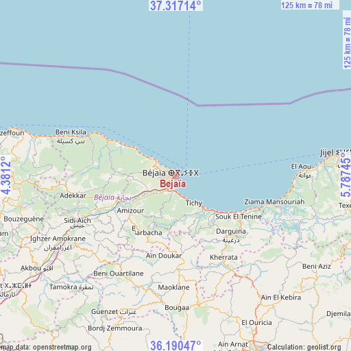
Bejaïa GPS coordinates[2]
36° 45' 21.132" North, 5° 5' 3.588" East
| Map corner | latitude | longitude |
|---|---|---|
| Upper-left | 37.31714°, | 4.3812° |
| Center: | 36.75587°, | 5.08433° |
| Lower-right: | 36.19047°, | 5.78745° |
| Map W x H: | 125.3×125.3 km | = 77.9×77.9mi |
| max Lat: | 36.92917° ⇑7.4% North |
| Bejaïa: | 36.75587° |
| min Lat: | ⇓92.6% South 22.785° |
| min Long | Bejaïa | max Long |
| -8.14743° | 5.08433° | 8.46667° |
| W 71.3%⇐ | ⇒28.7% E |
Elevation
Elevation of Bejaïa is 86 m = 282 ft, and this is 352.5 m = 1156 ft below average elevation for this country.
| Max E: |
1392 m = 4567 ft | 79.5% |
| Avg. | 438.5 m = 1439 ft | |
| Bejaïa | 86 m = 282 ft | |
Min E: |
5 m = 16 ft | 20.5% |
See also: Bejaïa elevation on elevation.city.
Geographical zone
Bejaïa is located in North temperate zone (between Tropic of Cancer and the Arctic Circle). Distance of this Northern Tropic circle is 1481 km =920.3 mi to South.| Distance of | km | miles | from Bejaïa |
|---|---|---|---|
| North Pole | 5920.2 | 3678.6 | to North |
| Arctic Circle | 3314.3 | 2059.4 | to North |
| Tropic Cancer | 1481 | 920.3 | to South |
| Equator | 4086.9 | 2539.5 | to South |


Nearby cities:
15 places around Bejaïa: (largest is in red/bold)
• Akbou
59.2 km =36.8 mi,  235°
235°
• Amizour
20.8 km =12.9 mi,  231°
231°
• Azazga
63.5 km =39.5 mi,  268°
268°
• Aïn Arnat
66.5 km =41.3 mi,  162°
162°
• BABOR - VILLE
50.2 km =31.2 mi,  126°
126°
• Barbacha
23.5 km =14.6 mi,  206°
206°
• Bordj Zemoura
57.2 km =35.5 mi,  200°
200°
• Bougaa
47 km =29.2 mi,  179°
179°
• Chemini
45.2 km =28.1 mi,  247°
247°
• El Kseur
22.1 km =13.7 mi, 247°
• Feraoun
29.9 km =18.6 mi,  223°
223°
• Ighram
61.1 km =38 mi, 237°
• Jijel
61.2 km =38 mi,  83°
83°
• Seddouk
42.4 km =26.3 mi, 236°
• el hed
30.1 km =18.7 mi, 246°
In other languages:
- In Spanish: Bugía
- In France: Béjaïa
- In German: Bejaia, Bidschāya
- In Italian: Bijaya
- In Russian: Беджая
Sources, notices
• [Note1] Compared only with cities in Algeria existing in our database
• [Src1] Map data: © OpenStreetMap contributors (CC-BY-SA)
• [Src2] Other city data from geonames.org with taken over terms of usage.
• [Src3] Geographical zone / Annual Mean Temperature by Robert A. Rohde @ Wikipedia
