Birine geodata
Birine (Djelfa) is a populated place; located in Algeria in Africa/Algiers (GMT+1) time zone. With population of 51,209 people, there are 98 cities with bigger population in this country. Compared to other cities in Algeria, 63.6% of cities are located further ↑North; 54.3% of cities are located further →East and 72.9% of cities have lower elevation than Birine. Note1


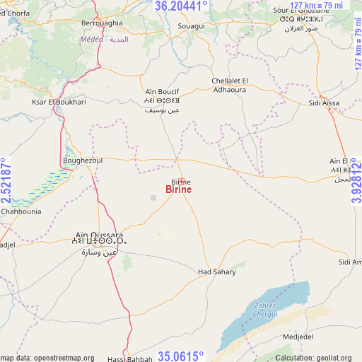
Birine GPS coordinates[2]
35° 38' 6" North, 3° 13' 30" East
| Map corner | latitude | longitude |
|---|---|---|
| Upper-left | 36.20441°, | 2.52187° |
| Center: | 35.635°, | 3.225° |
| Lower-right: | 35.0615°, | 3.92812° |
| Map W x H: | 127.1×127.1 km | = 79×79mi |
| max Lat: | 36.92917° ⇑63.6% North |
| Birine: | 35.635° |
| min Lat: | ⇓36.4% South 22.785° |
| min Long | Birine | max Long |
| -8.14743° | 3.225° | 8.46667° |
| W 45.7%⇐ | ⇒54.3% E |
Elevation
Elevation of Birine is 736 m = 2415 ft, and this is 297.5 m = 976 ft above average elevation for this country.
| Max E: |
1392 m = 4567 ft | 27.1% |
| Birine | 736 m 2415 ft | |
| Avg. | 438.5 m = 1439 ft | |
Min E: |
5 m = 16 ft | 72.9% |
See also: Birine elevation on elevation.city.
Geographical zone
Birine is located in North temperate zone (between Tropic of Cancer and the Arctic Circle). Distance of this Northern Tropic circle is 1356.3 km =842.8 mi to South.| Distance of | km | miles | from Birine |
|---|---|---|---|
| North Pole | 6044.8 | 3756.1 | to North |
| Arctic Circle | 3438.9 | 2136.8 | to North |
| Tropic Cancer | 1356.3 | 842.8 | to South |
| Equator | 3962.2 | 2462 | to South |


Nearby cities:
15 places around Birine: (largest is in red/bold)
• Aïn Bessem
83.6 km =51.9 mi,  28°
28°
• Aïn Oussera
35.4 km =22 mi,  234°
234°
• Berrouaghia
62.4 km =38.8 mi,  333°
333°
• Blida
99.5 km =61.8 mi,  338°
338°
• Bougara
101.7 km =63.2 mi,  352°
352°
• Boû Arfa
99.2 km =61.6 mi, 338°
• Dar Chioukh
85.5 km =53.1 mi,  163°
163°
• Ksar Chellala
94.6 km =58.8 mi,  240°
240°
• Ksar el Boukhari
51.4 km =31.9 mi,  303°
303°
• Melouza
94.8 km =58.9 mi,  66°
66°
• Médéa
81.8 km =50.8 mi, 328°
• Sidi Aïssa
56.7 km =35.2 mi,  60°
60°
• Sour el Ghozlane
70.8 km =44 mi,  36°
36°
• ‘Aïn el Hadjel
59.4 km =36.9 mi,  86°
86°
• ’Aïn Boucif
29.1 km =18.1 mi, 348°
Sources, notices
• [Note1] Compared only with cities in Algeria existing in our database
• [Src1] Map data: © OpenStreetMap contributors (CC-BY-SA)
• [Src2] Other city data from geonames.org with taken over terms of usage.
• [Src3] Geographical zone / Annual Mean Temperature by Robert A. Rohde @ Wikipedia
