Aïn Oussera geodata
Aïn Oussera (Djelfa) is a populated place; located in Algeria in Africa/Algiers (GMT+1) time zone. With population of 118,687 people, there are 35 cities with bigger population in this country. Compared to other cities in Algeria, 67.8% of cities are located further ↑North; 62.4% of cities are located further →East and 71.3% of cities have lower elevation than Aïn Oussera. Note1


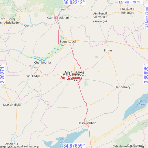
Aïn Oussera GPS coordinates[2]
35° 27' 5.004" North, 2° 54' 20.988" East
| Map corner | latitude | longitude |
|---|---|---|
| Upper-left | 36.02212°, | 2.20271° |
| Center: | 35.45139°, | 2.90583° |
| Lower-right: | 34.87659°, | 3.60896° |
| Map W x H: | 127.4×127.4 km | = 79.2×79.2mi |
| max Lat: | 36.92917° ⇑67.8% North |
| Aïn Oussera: | 35.45139° |
| min Lat: | ⇓32.2% South 22.785° |
| min Long | Aïn Oussera | max Long |
| -8.14743° | 2.90583° | 8.46667° |
| W 37.6%⇐ | ⇒62.4% E |
Elevation
Elevation of Aïn Oussera is 685 m = 2247 ft, and this is 246.5 m = 809 ft above average elevation for this country.
| Max E: |
1392 m = 4567 ft | 28.7% |
| Aïn Oussera | 685 m 2247 ft | |
| Avg. | 438.5 m = 1439 ft | |
Min E: |
5 m = 16 ft | 71.3% |
See also: Aïn Oussera elevation on elevation.city.
Geographical zone
Aïn Oussera is located in North temperate zone (between Tropic of Cancer and the Arctic Circle). Distance of this Northern Tropic circle is 1335.9 km =830.1 mi to South.| Distance of | km | miles | from Aïn Oussera |
|---|---|---|---|
| North Pole | 6065.2 | 3768.7 | to North |
| Arctic Circle | 3459.3 | 2149.5 | to North |
| Tropic Cancer | 1335.9 | 830.1 | to South |
| Equator | 3941.8 | 2449.3 | to South |


Nearby cities:
15 places around Aïn Oussera: (largest is in red/bold)
• Berrouaghia
76 km =47.2 mi,  0°
0°
• Birine
35.4 km =22 mi,  54°
54°
• Charef
92.9 km =57.7 mi,  186°
186°
• Dar Chioukh
81.1 km =50.4 mi,  139°
139°
• Djelfa
92.5 km =57.5 mi,  159°
159°
• Ksar Chellala
59.5 km =37 mi,  243°
243°
• Ksar el Boukhari
50.7 km =31.5 mi,  343°
343°
• Mehdia daira de meghila
104.1 km =64.7 mi,  268°
268°
• Médéa
91.4 km =56.8 mi,  351°
351°
• Sidi Aïssa
92 km =57.2 mi,  58°
58°
• Sour el Ghozlane
104.9 km =65.2 mi,  42°
42°
• Theniet el Had
92 km =57.2 mi,  300°
300°
• Tissemsilt
100.6 km =62.5 mi,  279°
279°
• ‘Aïn el Hadjel
91.5 km =56.9 mi,  74°
74°
• ’Aïn Boucif
54 km =33.6 mi,  25°
25°
Sources, notices
• [Note1] Compared only with cities in Algeria existing in our database
• [Src1] Map data: © OpenStreetMap contributors (CC-BY-SA)
• [Src2] Other city data from geonames.org with taken over terms of usage.
• [Src3] Geographical zone / Annual Mean Temperature by Robert A. Rohde @ Wikipedia
