Nueva Loja geodata
Nueva Loja (Sucumbios) is a seat of a first-order administrative division; located in Ecuador in America/Guayaquil (GMT-5) time zone. With population of 24,211 people, there are 45 cities with bigger population in this country. Compared to other cities in Ecuador, 87.6% of cities are located further ↓South; 100% of cities are located further ←West and 52.9% of cities have lower elevation than Nueva Loja. Note1


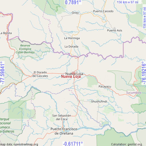
Nueva Loja GPS coordinates[2]
0° 5' 9.6" North, 76° 53' 43.008" West
| Map corner | latitude | longitude |
|---|---|---|
| Upper-left | 0.7891°, | -77.59841° |
| Center: | 0.086°, | -76.89528° |
| Lower-right: | -0.61711°, | -76.19216° |
| Map W x H: | 156.4×156.4 km | = 97.2×97.2mi |
| max Lat: | 1.35251° ⇑12.4% North |
| Nueva Loja: | 0.086° |
| min Lat: | ⇓87.6% South -4.38181° |
| min Long | Nueva Loja | max Long |
| -90.96654° | -76.89528° | -76.89528° |
| W 100%⇐ | ⇒0% E |
Elevation
Elevation of Nueva Loja is 303 m = 994 ft, and this is 642.1 m = 2107 ft below average elevation for this country.
| Max E: |
3131 m = 10272 ft | 47.1% |
| Avg. | 945.1 m = 3101 ft | |
| Nueva Loja | 303 m = 994 ft | |
Min E: |
1 m = 3 ft | 52.9% |
See also: Ecuador elevation on elevation.city.
Geographical zone
Nueva Loja is located in North Torrid zone (between Equator and Tropic of Cancer). Distance of Equator is 9.6 km =6 mi to South.| Distance of | km | miles | from Nueva Loja |
|---|---|---|---|
| North Pole | 9997.5 | 6212.2 | to North |
| Arctic Circle | 7391.6 | 4592.9 | to North |
| Tropic Cancer | 2596.4 | 1613.3 | to North |
| Equator | 9.6 | 6 | to South |


Nearby cities:
15 places around Nueva Loja: (largest is in red/bold)
• Archidona
150.1 km =93.3 mi,  222°
222°
• Atuntaqui
149.1 km =92.6 mi,  280°
280°
• Boca Suno
91.4 km =56.8 mi,  197°
197°
• Cayambe
139.1 km =86.4 mi,  267°
267°
• Cotacachi
154.1 km =95.8 mi, 278°
• El Ángel
130.6 km =81.2 mi,  297°
297°
• Gonzalo Pizarro
54.4 km =33.8 mi,  261°
261°
• Ibarra
139.6 km =86.7 mi, 282°
• Otavalo
152.9 km =95 mi, 276°
• Pimampiro
121.1 km =75.2 mi,  286°
286°
• Puerto Francisco de Orellana
62.3 km =38.7 mi,  189°
189°
• San Gabriel
118.3 km =73.5 mi, 298°
• Sangolquí
179.3 km =111.4 mi,  254°
254°
• Tena
157.6 km =97.9 mi, 220°
• Tulcán
121.9 km =75.7 mi,  311°
311°
Sources, notices
• [Note1] Compared only with cities in Ecuador existing in our database
• [Src1] Map data: © OpenStreetMap contributors (CC-BY-SA)
• [Src2] Other city data from geonames.org with taken over terms of usage.
• [Src3] Geographical zone / Annual Mean Temperature by Robert A. Rohde @ Wikipedia
