Sohag geodata
Sohag is a seat of a first-order administrative division; located in Egypt in Africa/Cairo (GMT+2) time zone. With population of 209,419 people, there are 20 cities with bigger population in this country. Compared to other cities in Egypt, 87.7% of cities are located further ↑North; 68.1% of cities are located further ←West and 84.8% of cities have lower elevation than Sohag. Note1


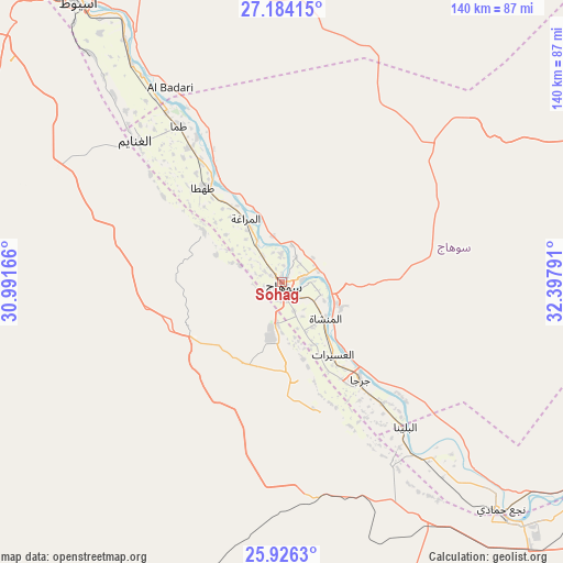
Sohag GPS coordinates[2]
26° 33' 25.02" North, 31° 41' 41.208" East
| Map corner | latitude | longitude |
|---|---|---|
| Upper-left | 27.18415°, | 30.99166° |
| Center: | 26.55695°, | 31.69478° |
| Lower-right: | 25.9263°, | 32.39791° |
| Map W x H: | 139.9×139.9 km | = 86.9×86.9mi |
| max Lat: | 31.5084° ⇑87.7% North |
| Sohag: | 26.55695° |
| min Lat: | ⇓12.3% South 22.3457° |
| min Long | Sohag | max Long |
| 25.51965° | 31.69478° | 34.89572° |
| W 68.1%⇐ | ⇒31.9% E |
Elevation
Elevation of Sohag is 67 m = 220 ft, and this is 23.5 m = 77 ft above average elevation for this country.
| Max E: |
1565 m = 5135 ft | 15.2% |
| Sohag | 67 m 220 ft | |
| Avg. | 43.5 m = 143 ft | |
Min E: |
-15 m = -49 ft | 84.8% |
See also: Sohag elevation on elevation.city.
Geographical zone
Sohag is located in North temperate zone (between Tropic of Cancer and the Arctic Circle). Distance of this Northern Tropic circle is 346.9 km =215.6 mi to South.| Distance of | km | miles | from Sohag |
|---|---|---|---|
| North Pole | 7054.2 | 4383.3 | to North |
| Arctic Circle | 4448.3 | 2764 | to North |
| Tropic Cancer | 346.9 | 215.6 | to South |
| Equator | 2952.9 | 1834.8 | to South |


Nearby cities:
15 places around Sohag: (largest is in red/bold)
• Abnūb
95.8 km =59.5 mi,  325°
325°
• Abū Tīj
65.8 km =40.9 mi, 325°
• Akhmīm
5 km =3.1 mi,  83°
83°
• Al Badārī
55.8 km =34.7 mi, 330°
• Al Balyanā
47.1 km =29.3 mi,  139°
139°
• Al Manshāh
14 km =8.7 mi,  129°
129°
• Asyūţ
85.9 km =53.4 mi,  323°
323°
• Dishnā
91.5 km =56.9 mi,  121°
121°
• Farshūţ
72.8 km =45.2 mi, 140°
• Jirjā
31.2 km =19.4 mi, 141°
• Juhaynah
23.5 km =14.6 mi,  303°
303°
• Manfalūţ
110.4 km =68.6 mi, 319°
• Naja' Ḥammādī
78.4 km =48.7 mi, 136°
• Qinā
111.7 km =69.4 mi,  113°
113°
• Ţahţā
30.4 km =18.9 mi, 320°
Sources, notices
• [Note1] Compared only with cities in Egypt existing in our database
• [Src1] Map data: © OpenStreetMap contributors (CC-BY-SA)
• [Src2] Other city data from geonames.org with taken over terms of usage.
• [Src3] Geographical zone / Annual Mean Temperature by Robert A. Rohde @ Wikipedia
