Akhmīm geodata
Akhmīm (Sohag) is a populated place; located in Egypt in Africa/Cairo (GMT+2) time zone. With population of 99,446 people, there are 38 cities with bigger population in this country. Compared to other cities in Egypt, 87% of cities are located further ↑North; 70.3% of cities are located further ←West and 92.8% of cities have lower elevation than Akhmīm. Note1


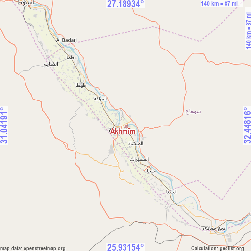
Akhmīm GPS coordinates[2]
26° 33' 43.812" North, 31° 44' 42.108" East
| Map corner | latitude | longitude |
|---|---|---|
| Upper-left | 27.18934°, | 31.04191° |
| Center: | 26.56217°, | 31.74503° |
| Lower-right: | 25.93154°, | 32.44816° |
| Map W x H: | 139.9×139.9 km | = 86.9×86.9mi |
| max Lat: | 31.5084° ⇑87% North |
| Akhmīm: | 26.56217° |
| min Lat: | ⇓13% South 22.3457° |
| min Long | Akhmīm | max Long |
| 25.51965° | 31.74503° | 34.89572° |
| W 70.3%⇐ | ⇒29.7% E |
Elevation
Elevation of Akhmīm is 85 m = 279 ft, and this is 41.5 m = 136 ft above average elevation for this country.
| Max E: |
1565 m = 5135 ft | 7.2% |
| Akhmīm | 85 m 279 ft | |
| Avg. | 43.5 m = 143 ft | |
Min E: |
-15 m = -49 ft | 92.8% |
See also: Akhmīm elevation on elevation.city.
Geographical zone
Akhmīm is located in North temperate zone (between Tropic of Cancer and the Arctic Circle). Distance of this Northern Tropic circle is 347.5 km =215.9 mi to South.| Distance of | km | miles | from Akhmīm |
|---|---|---|---|
| North Pole | 7053.6 | 4382.9 | to North |
| Arctic Circle | 4447.7 | 2763.7 | to North |
| Tropic Cancer | 347.5 | 215.9 | to South |
| Equator | 2953.4 | 1835.2 | to South |


Nearby cities:
15 places around Akhmīm: (largest is in red/bold)
• Abnūb
98.3 km =61.1 mi,  323°
323°
• Abū Tīj
68.3 km =42.4 mi, 321°
• Al Badārī
58 km =36 mi,  325°
325°
• Al Balyanā
44.5 km =27.7 mi,  144°
144°
• Al Manshāh
11.1 km =6.9 mi,  148°
148°
• Asyūţ
88.5 km =55 mi, 321°
• Dishnā
87.6 km =54.4 mi,  123°
123°
• Farshūţ
70.1 km =43.6 mi, 143°
• Jirjā
28.9 km =18 mi, 149°
• Juhaynah
27.5 km =17.1 mi,  296°
296°
• Manfalūţ
113.2 km =70.3 mi, 317°
• Naja' Ḥammādī
75.5 km =46.9 mi, 139°
• Qinā
107.3 km =66.7 mi,  114°
114°
• Sohag
5 km =3.1 mi,  263°
263°
• Ţahţā
33.4 km =20.8 mi,  313°
313°
Sources, notices
• [Note1] Compared only with cities in Egypt existing in our database
• [Src1] Map data: © OpenStreetMap contributors (CC-BY-SA)
• [Src2] Other city data from geonames.org with taken over terms of usage.
• [Src3] Geographical zone / Annual Mean Temperature by Robert A. Rohde @ Wikipedia
