Arish geodata
Arish (North Sinai) is a seat of a first-order administrative division; located in Egypt in Africa/Cairo (GMT+2) time zone. With population of 128,855 people, there are 31 cities with bigger population in this country. Compared to other cities in Egypt, 84.1% of cities are located further ↓South; 91.3% of cities are located further ←West and 61.6% of cities have higher elevation than Arish. Note1


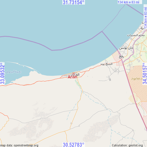
Arish GPS coordinates[2]
31° 7' 53.724" North, 33° 47' 54.384" East
| Map corner | latitude | longitude |
|---|---|---|
| Upper-left | 31.73154°, | 33.09532° |
| Center: | 31.13159°, | 33.79844° |
| Lower-right: | 30.52783°, | 34.50157° |
| Map W x H: | 133.8×133.8 km | = 83.1×83.1mi |
| max Lat: | 31.5084° ⇑15.9% North |
| Arish: | 31.13159° |
| min Lat: | ⇓84.1% South 22.3457° |
| min Long | Arish | max Long |
| 25.51965° | 33.79844° | 34.89572° |
| W 91.3%⇐ | ⇒8.7% E |
Elevation
Elevation of Arish is 15 m = 49 ft, and this is 28.5 m = 94 ft below average elevation for this country.
| Max E: |
1565 m = 5135 ft | 61.6% |
| Avg. | 43.5 m = 143 ft | |
| Arish | 15 m = 49 ft | |
Min E: |
-15 m = -49 ft | 38.4% |
See also: Arish elevation on elevation.city.
Geographical zone
Arish is located in North temperate zone (between Tropic of Cancer and the Arctic Circle). Distance of this Northern Tropic circle is 855.6 km =531.6 mi to South.| Distance of | km | miles | from Arish |
|---|---|---|---|
| North Pole | 6545.6 | 4067.2 | to North |
| Arctic Circle | 3939.7 | 2448 | to North |
| Tropic Cancer | 855.6 | 531.6 | to South |
| Equator | 3461.5 | 2150.9 | to South |


Nearby cities:
15 places around Arish: (largest is in red/bold)
• Al Jammālīyah
184.1 km =114.4 mi,  271°
271°
• Al Manzalah
177.3 km =110.2 mi, 270°
• Al Maţarīyah
168.3 km =104.6 mi, 271°
• Al Qurayn
205.1 km =127.4 mi,  253°
253°
• Ash Shaykh Zuwayd
31.2 km =19.4 mi,  72°
72°
• At Tall al Kabīr
203 km =126.1 mi, 251°
• Bi’r al ‘Abd
76.1 km =47.3 mi,  260°
260°
• Damietta
191.3 km =118.9 mi,  279°
279°
• Fāqūs
196.1 km =121.9 mi, 256°
• Fāraskūr
199.3 km =123.8 mi, 276°
• Ismailia
157 km =97.6 mi, 248°
• Port Said
144.7 km =89.9 mi, 275°
• Rafaḩ
45.1 km =28 mi, 68°
• Suez
177.2 km =110.1 mi,  223°
223°
• ‘Izbat al Burj
190.6 km =118.4 mi, 282°
In other languages:
- In Spanish: El Arish
- In France: El-Arich
- In German: Al-Arisch
- In Italian: Al-Arish
- In Russian: Эль-Ариш
- In Chinese: 阿里什
Sources, notices
• [Note1] Compared only with cities in Egypt existing in our database
• [Src1] Map data: © OpenStreetMap contributors (CC-BY-SA)
• [Src2] Other city data from geonames.org with taken over terms of usage.
• [Src3] Geographical zone / Annual Mean Temperature by Robert A. Rohde @ Wikipedia
