Puerto Serrano geodata
Puerto Serrano (Andalusia) is a populated place; located in Spain in Europe/Madrid (GMT+2) time zone. With population of 6,807 people, there are 1056 cities with bigger population in this country. Compared to other cities in Spain, 95.9% of cities are located further ↑North; 79.3% of cities are located further →East and 83.2% of cities have higher elevation than Puerto Serrano. Note1


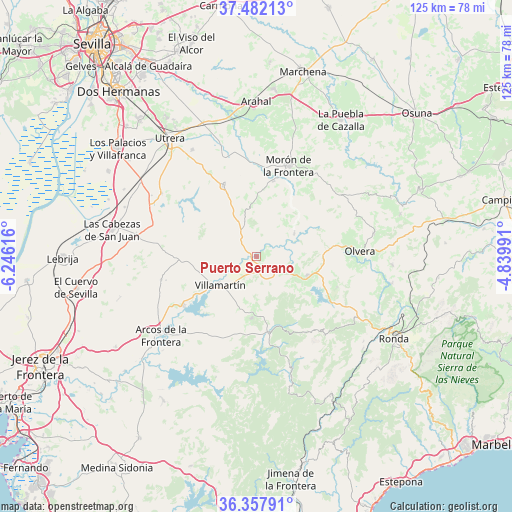
Puerto Serrano GPS coordinates[2]
36° 55' 19.524" North, 5° 32' 34.944" West
| Map corner | latitude | longitude |
|---|---|---|
| Upper-left | 37.48213°, | -6.24616° |
| Center: | 36.92209°, | -5.54304° |
| Lower-right: | 36.35791°, | -4.83991° |
| Map W x H: | 125×125 km | = 77.7×77.7mi |
| max Lat: | 43.74134° ⇑95.9% North |
| Puerto Serrano: | 36.92209° |
| min Lat: | ⇓4.1% South 27.64134° |
| min Long | Puerto Serrano | max Long |
| -18.00367° | -5.54304° | 4.2899° |
| W 20.7%⇐ | ⇒79.3% E |
Elevation
Elevation of Puerto Serrano is 166 m = 545 ft, and this is 432 m = 1417 ft below average elevation for this country.
| Max E: |
1682 m = 5518 ft | 83.2% |
| Avg. | 598 m = 1962 ft | |
| Puerto Serrano | 166 m = 545 ft | |
Min E: |
0 m = 0 ft | 16.8% |
See also: Spain elevation on elevation.city.
Geographical zone
Puerto Serrano is located in North temperate zone (between Tropic of Cancer and the Arctic Circle). Distance of this Northern Tropic circle is 1499.4 km =931.7 mi to South.| Distance of | km | miles | from Puerto Serrano |
|---|---|---|---|
| North Pole | 5901.7 | 3667.1 | to North |
| Arctic Circle | 3295.8 | 2047.9 | to North |
| Tropic Cancer | 1499.4 | 931.7 | to South |
| Equator | 4105.4 | 2551 | to South |


Nearby cities:
15 places around Puerto Serrano: (largest is in red/bold)
• Algodonales
13.1 km =8.1 mi,  110°
110°
• Bornos
21.4 km =13.3 mi,  236°
236°
• Coripe
10.8 km =6.7 mi,  58°
58°
• El Bosque
18.5 km =11.5 mi,  169°
169°
• El Coronil
19.3 km =12 mi,  335°
335°
• El Gastor
20.9 km =13 mi, 110°
• Espera
24 km =14.9 mi,  257°
257°
• Grazalema
23.8 km =14.8 mi,  139°
139°
• Montecorto
24.8 km =15.4 mi,  118°
118°
• Montellano
8.5 km =5.3 mi, 342°
• Morón de la Frontera
23.5 km =14.6 mi,  19°
19°
• Olvera
24.6 km =15.3 mi,  86°
86°
• Prado del Rey
15 km =9.3 mi,  184°
184°
• Villamartín
11.4 km =7.1 mi,  232°
232°
• Zahara
16.3 km =10.1 mi, 123°
Sources, notices
• [Note1] Compared only with cities in Spain existing in our database
• [Src1] Map data: © OpenStreetMap contributors (CC-BY-SA)
• [Src2] Other city data from geonames.org with taken over terms of usage.
• [Src3] Geographical zone / Annual Mean Temperature by Robert A. Rohde @ Wikipedia
