Tobarra geodata
Tobarra (Castille-La Mancha) is a seat of a third-order administrative division; located in Spain in Europe/Madrid (GMT+2) time zone. With population of 7,884 people, there are 950 cities with bigger population in this country. Compared to other cities in Spain, 85.1% of cities are located further ↑North; 70.7% of cities are located further ←West and 50.8% of cities have higher elevation than Tobarra. Note1
Administrative division(s):
- Level 1: Castille-La Mancha
- Level 2: Provincia de Albacete
- Level 3: Tobarra


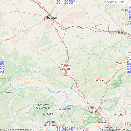
Tobarra GPS coordinates[2]
38° 35' 31.668" North, 1° 41' 30.876" West
| Map corner | latitude | longitude |
|---|---|---|
| Upper-left | 39.13959°, | -2.39504° |
| Center: | 38.59213°, | -1.69191° |
| Lower-right: | 38.04046°, | -0.98879° |
| Map W x H: | 122.2×122.2 km | = 75.9×75.9mi |
| max Lat: | 43.74134° ⇑85.1% North |
| Tobarra: | 38.59213° |
| min Lat: | ⇓14.9% South 27.64134° |
| min Long | Tobarra | max Long |
| -18.00367° | -1.69191° | 4.2899° |
| W 70.7%⇐ | ⇒29.3% E |
Elevation
Elevation of Tobarra is 650 m = 2133 ft, and this is 52 m = 171 ft above average elevation for this country.
| Max E: |
1682 m = 5518 ft | 50.8% |
| Tobarra | 650 m 2133 ft | |
| Avg. | 598 m = 1962 ft | |
Min E: |
0 m = 0 ft | 49.2% |
See also: Spain elevation on elevation.city.
Geographical zone
Tobarra is located in North temperate zone (between Tropic of Cancer and the Arctic Circle). Distance of this Northern Tropic circle is 1685.1 km =1047.1 mi to South.| Distance of | km | miles | from Tobarra |
|---|---|---|---|
| North Pole | 5716 | 3551.8 | to North |
| Arctic Circle | 3110.1 | 1932.5 | to North |
| Tropic Cancer | 1685.1 | 1047.1 | to South |
| Equator | 4291 | 2666.3 | to South |


Nearby cities:
15 places around Tobarra: (largest is in red/bold)
• Albatana
15 km =9.3 mi,  99°
99°
• Alcadozo
25.8 km =16 mi,  284°
284°
• Ayna
34.3 km =21.3 mi,  262°
262°
• Chinchilla de Monte Aragón
36.6 km =22.7 mi,  356°
356°
• Corral-Rubio
33.6 km =20.9 mi,  36°
36°
• Elche de la Sierra
34.7 km =21.6 mi,  243°
243°
• Fuente-Álamo
25.2 km =15.7 mi,  63°
63°
• Hellín
9.1 km =5.7 mi,  184°
184°
• Jumilla
34.3 km =21.3 mi,  111°
111°
• Liétor
23.4 km =14.5 mi, 256°
• Ontur
17.1 km =10.6 mi,  81°
81°
• Peñas de San Pedro
31.1 km =19.3 mi,  299°
299°
• Pozo-Cañada
23.8 km =14.8 mi,  350°
350°
• Pozohondo
23.9 km =14.9 mi,  306°
306°
• Pétrola
28.6 km =17.8 mi,  24°
24°
Sources, notices
• [Note1] Compared only with cities in Spain existing in our database
• [Src1] Map data: © OpenStreetMap contributors (CC-BY-SA)
• [Src2] Other city data from geonames.org with taken over terms of usage.
• [Src3] Geographical zone / Annual Mean Temperature by Robert A. Rohde @ Wikipedia
