Balanegra geodata
Balanegra (Andalusia) is a seat of a third-order administrative division; located in Spain in Europe/Madrid (GMT+2) time zone. In our database, there are 6762 cities with bigger population. Compared to other cities in Spain, 97.2% of cities are located further ↑North; 55.8% of cities are located further ←West and 97% of cities have higher elevation than Balanegra. Note1


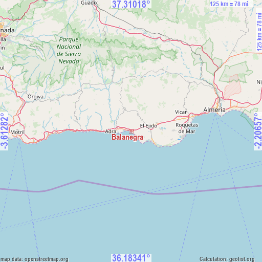
Balanegra GPS coordinates[2]
36° 44' 55.896" North, 2° 54' 34.92" West
| Map corner | latitude | longitude |
|---|---|---|
| Upper-left | 37.31018°, | -3.61282° |
| Center: | 36.74886°, | -2.9097° |
| Lower-right: | 36.18341°, | -2.20657° |
| Map W x H: | 125.3×125.3 km | = 77.9×77.9mi |
| max Lat: | 43.74134° ⇑97.2% North |
| Balanegra: | 36.74886° |
| min Lat: | ⇓2.8% South 27.64134° |
| min Long | Balanegra | max Long |
| -18.00367° | -2.9097° | 4.2899° |
| W 55.8%⇐ | ⇒44.2% E |
Elevation
Elevation of Balanegra is 15 m = 49 ft, and this is 583 m = 1913 ft below average elevation for this country.
| Max E: |
1682 m = 5518 ft | 97% |
| Avg. | 598 m = 1962 ft | |
| Balanegra | 15 m = 49 ft | |
Min E: |
0 m = 0 ft | 3% |
See also: Spain elevation on elevation.city.
Geographical zone
Balanegra is located in North temperate zone (between Tropic of Cancer and the Arctic Circle). Distance of this Northern Tropic circle is 1480.2 km =919.8 mi to South.| Distance of | km | miles | from Balanegra |
|---|---|---|---|
| North Pole | 5921 | 3679.1 | to North |
| Arctic Circle | 3315.1 | 2059.9 | to North |
| Tropic Cancer | 1480.2 | 919.8 | to South |
| Equator | 4086.1 | 2539 | to South |


Nearby cities:
15 places around Balanegra: (largest is in red/bold)
• Adra
9.9 km =6.2 mi,  270°
270°
• Albuñol
26.7 km =16.6 mi,  280°
280°
• Alcolea
25.5 km =15.8 mi,  349°
349°
• Berja
11.5 km =7.1 mi,  341°
341°
• Dalías
8.8 km =5.5 mi,  22°
22°
• Darrícal
21.8 km =13.5 mi,  330°
330°
• El Ejido
9 km =5.6 mi,  70°
70°
• Fondón
26.1 km =16.2 mi,  9°
9°
• Félix
26.1 km =16.2 mi,  59°
59°
• La Gangosa Vistasol
26.4 km =16.4 mi,  76°
76°
• Laujar de Andarax
27.4 km =17 mi,  3°
3°
• Murtas
23.4 km =14.5 mi,  310°
310°
• Roquetas de Mar
26.3 km =16.3 mi,  86°
86°
• Ugíjar
26.9 km =16.7 mi, 331°
• Vícar
25.5 km =15.8 mi, 68°
Sources, notices
• [Note1] Compared only with cities in Spain existing in our database
• [Src1] Map data: © OpenStreetMap contributors (CC-BY-SA)
• [Src2] Other city data from geonames.org with taken over terms of usage.
• [Src3] Geographical zone / Annual Mean Temperature by Robert A. Rohde @ Wikipedia
