Cedillo geodata
Cedillo (Extremadura) is a seat of a third-order administrative division; located in Spain in Europe/Madrid (GMT+2) time zone. With population of 574 people, there are 3671 cities with bigger population in this country. Compared to other cities in Spain, 75% of cities are located further ↑North; 95.4% of cities are located further →East and 77% of cities have higher elevation than Cedillo. Note1


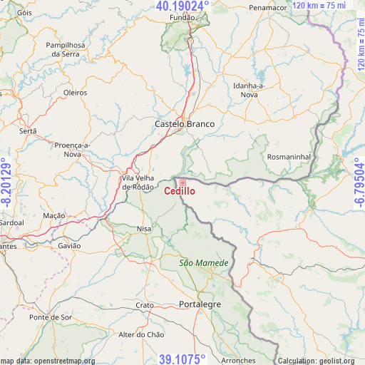
Cedillo GPS coordinates[2]
39° 39' 3.564" North, 7° 29' 53.412" West
| Map corner | latitude | longitude |
|---|---|---|
| Upper-left | 40.19024°, | -8.20129° |
| Center: | 39.65099°, | -7.49817° |
| Lower-right: | 39.1075°, | -6.79504° |
| Map W x H: | 120.4×120.4 km | = 74.8×74.8mi |
| max Lat: | 43.74134° ⇑75% North |
| Cedillo: | 39.65099° |
| min Lat: | ⇓25% South 27.64134° |
| min Long | Cedillo | max Long |
| -18.00367° | -7.49817° | 4.2899° |
| W 4.6%⇐ | ⇒95.4% E |
Elevation
Elevation of Cedillo is 269 m = 883 ft, and this is 329 m = 1079 ft below average elevation for this country.
| Max E: |
1682 m = 5518 ft | 77% |
| Avg. | 598 m = 1962 ft | |
| Cedillo | 269 m = 883 ft | |
Min E: |
0 m = 0 ft | 23% |
See also: Spain elevation on elevation.city.
Geographical zone
Cedillo is located in North temperate zone (between Tropic of Cancer and the Arctic Circle). Distance of this Northern Tropic circle is 1802.9 km =1120.3 mi to South.| Distance of | km | miles | from Cedillo |
|---|---|---|---|
| North Pole | 5598.3 | 3478.6 | to North |
| Arctic Circle | 2992.4 | 1859.4 | to North |
| Tropic Cancer | 1802.9 | 1120.3 | to South |
| Equator | 4408.8 | 2739.5 | to South |


Nearby cities:
15 places around Cedillo: (largest is in red/bold)
• Alburquerque
64 km =39.8 mi,  138°
138°
• Alcántara
53.1 km =33 mi,  81°
81°
• Brozas
61.8 km =38.4 mi,  93°
93°
• Carbajo
26.4 km =16.4 mi,  101°
101°
• Herrera de Alcántara
8 km =5 mi, 99°
• La Codosera
56.5 km =35.1 mi,  150°
150°
• Mata de Alcántara
58.6 km =36.4 mi, 82°
• Membrío
40.5 km =25.2 mi,  109°
109°
• Piedras Albas
51.1 km =31.8 mi,  73°
73°
• Salorino
46.1 km =28.6 mi, 114°
• San Vicente de Alcántara
44.7 km =27.8 mi, 136°
• Santiago de Alcántara
22.3 km =13.9 mi, 102°
• Valencia de Alcántara
34.4 km =21.4 mi, 140°
• Villa del Rey
58 km =36 mi, 89°
• Zarza la Mayor
59.9 km =37.2 mi, 65°
Sources, notices
• [Note1] Compared only with cities in Spain existing in our database
• [Src1] Map data: © OpenStreetMap contributors (CC-BY-SA)
• [Src2] Other city data from geonames.org with taken over terms of usage.
• [Src3] Geographical zone / Annual Mean Temperature by Robert A. Rohde @ Wikipedia
