Almedinilla geodata
Almedinilla (Andalusia) is a seat of a third-order administrative division; located in Spain in Europe/Madrid (GMT+2) time zone. With population of 2,561 people, there are 1878 cities with bigger population in this country. Compared to other cities in Spain, 91.6% of cities are located further ↑North; 61.1% of cities are located further →East and 51.9% of cities have higher elevation than Almedinilla. Note1


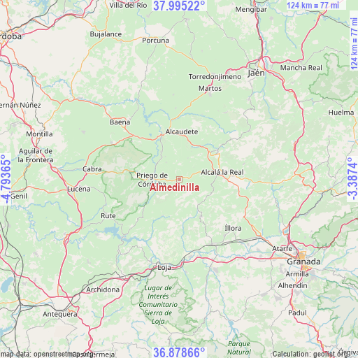
Almedinilla GPS coordinates[2]
37° 26' 20.472" North, 4° 5' 25.872" West
| Map corner | latitude | longitude |
|---|---|---|
| Upper-left | 37.99522°, | -4.79365° |
| Center: | 37.43902°, | -4.09052° |
| Lower-right: | 36.87866°, | -3.3874° |
| Map W x H: | 124.1×124.1 km | = 77.1×77.1mi |
| max Lat: | 43.74134° ⇑91.6% North |
| Almedinilla: | 37.43902° |
| min Lat: | ⇓8.4% South 27.64134° |
| min Long | Almedinilla | max Long |
| -18.00367° | -4.09052° | 4.2899° |
| W 38.9%⇐ | ⇒61.1% E |
Elevation
Elevation of Almedinilla is 638 m = 2093 ft, and this is 40 m = 131 ft above average elevation for this country.
| Max E: |
1682 m = 5518 ft | 51.9% |
| Almedinilla | 638 m 2093 ft | |
| Avg. | 598 m = 1962 ft | |
Min E: |
0 m = 0 ft | 48.1% |
See also: Spain elevation on elevation.city.
Geographical zone
Almedinilla is located in North temperate zone (between Tropic of Cancer and the Arctic Circle). Distance of this Northern Tropic circle is 1556.9 km =967.4 mi to South.| Distance of | km | miles | from Almedinilla |
|---|---|---|---|
| North Pole | 5844.2 | 3631.4 | to North |
| Arctic Circle | 3238.3 | 2012.2 | to North |
| Tropic Cancer | 1556.9 | 967.4 | to South |
| Equator | 4162.8 | 2586.6 | to South |


Nearby cities:
15 places around Almedinilla: (largest is in red/bold)
• Alcalá la Real
15 km =9.3 mi,  80°
80°
• Alcaudete
16.9 km =10.5 mi,  2°
2°
• Algarinejo
14 km =8.7 mi,  205°
205°
• Carcabuey
16.3 km =10.1 mi,  272°
272°
• Castillo de Locubín
16.4 km =10.2 mi,  52°
52°
• Doña Mencía
26.7 km =16.6 mi,  298°
298°
• Frailes
22.9 km =14.2 mi, 76°
• Fuente-Tójar
9.4 km =5.8 mi,  328°
328°
• Illora
25 km =15.5 mi,  132°
132°
• Luque
21.3 km =13.2 mi,  308°
308°
• Montefrío
14.8 km =9.2 mi,  150°
150°
• Priego de Córdoba
9.2 km =5.7 mi, 269°
• Villanueva de Mesía
25.9 km =16.1 mi,  164°
164°
• Zagra
21.5 km =13.4 mi,  198°
198°
• Zuheros
23 km =14.3 mi, 300°
Sources, notices
• [Note1] Compared only with cities in Spain existing in our database
• [Src1] Map data: © OpenStreetMap contributors (CC-BY-SA)
• [Src2] Other city data from geonames.org with taken over terms of usage.
• [Src3] Geographical zone / Annual Mean Temperature by Robert A. Rohde @ Wikipedia
