Ponts geodata
Ponts (Catalonia) is a populated place; located in Spain in Europe/Madrid (GMT+2) time zone. With population of 2,361 people, there are 1960 cities with bigger population in this country. Compared to other cities in Spain, 71.2% of cities are located further ↓South; 91% of cities are located further ←West and 71.2% of cities have higher elevation than Ponts. Note1
Administrative division(s):
- Level 1: Catalonia
- Level 2: Província de Lleida
- Level 3: Torrefeta i Florejacs


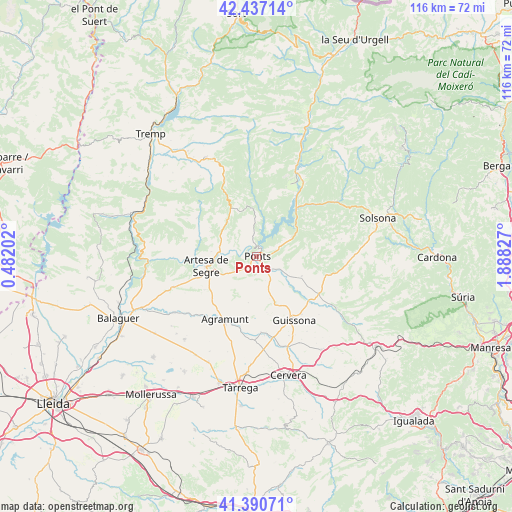
Ponts GPS coordinates[2]
41° 54' 57.852" North, 1° 11' 6.54" East
| Map corner | latitude | longitude |
|---|---|---|
| Upper-left | 42.43714°, | 0.48202° |
| Center: | 41.91607°, | 1.18515° |
| Lower-right: | 41.39071°, | 1.88827° |
| Map W x H: | 116.4×116.4 km | = 72.3×72.3mi |
| max Lat: | 43.74134° ⇑28.8% North |
| Ponts: | 41.91607° |
| min Lat: | ⇓71.2% South 27.64134° |
| min Long | Ponts | max Long |
| -18.00367° | 1.18515° | 4.2899° |
| W 91%⇐ | ⇒9% E |
Elevation
Elevation of Ponts is 364 m = 1194 ft, and this is 234 m = 768 ft below average elevation for this country.
| Max E: |
1682 m = 5518 ft | 71.2% |
| Avg. | 598 m = 1962 ft | |
| Ponts | 364 m = 1194 ft | |
Min E: |
0 m = 0 ft | 28.8% |
See also: Spain elevation on elevation.city.
Geographical zone
Ponts is located in North temperate zone (between Tropic of Cancer and the Arctic Circle). Distance of this Northern Tropic circle is 2054.7 km =1276.7 mi to South.| Distance of | km | miles | from Ponts |
|---|---|---|---|
| North Pole | 5346.4 | 3322.1 | to North |
| Arctic Circle | 2740.5 | 1702.9 | to North |
| Tropic Cancer | 2054.7 | 1276.7 | to South |
| Equator | 4660.6 | 2896 | to South |


Nearby cities:
15 places around Ponts: (largest is in red/bold)
• Agramunt
16.1 km =10 mi,  206°
206°
• Artesa de Segre
11.7 km =7.3 mi,  258°
258°
• Camarasa
25.8 km =16 mi, 259°
• Castellfollit de Riubregós
26.4 km =16.4 mi,  128°
128°
• Castellserà
24 km =14.9 mi,  219°
219°
• Cubells
20.1 km =12.5 mi,  248°
248°
• Ivorra
24.3 km =15.1 mi, 133°
• Montgai
22.2 km =13.8 mi,  234°
234°
• Oliana
20 km =12.4 mi,  31°
31°
• Ossó de Sió
18.1 km =11.2 mi,  186°
186°
• Penelles
25.9 km =16.1 mi, 224°
• Preixens
17.4 km =10.8 mi, 219°
• Tiurana
8.8 km =5.5 mi,  41°
41°
• Tornabous
26.3 km =16.3 mi,  204°
204°
• Torà de Riubregós
20.9 km =13 mi,  121°
121°
Sources, notices
• [Note1] Compared only with cities in Spain existing in our database
• [Src1] Map data: © OpenStreetMap contributors (CC-BY-SA)
• [Src2] Other city data from geonames.org with taken over terms of usage.
• [Src3] Geographical zone / Annual Mean Temperature by Robert A. Rohde @ Wikipedia
