Turmi geodata
Turmi (SNNPR) is a populated place; located in Ethiopia in Africa/Addis_Ababa (GMT+3) time zone. With population of 1,087 people, there are 106 cities with bigger population in this country. Compared to other cities in Ethiopia, 97.2% of cities are located further ↑North; 87.9% of cities are located further →East and 94.4% of cities have higher elevation than Turmi. Note1


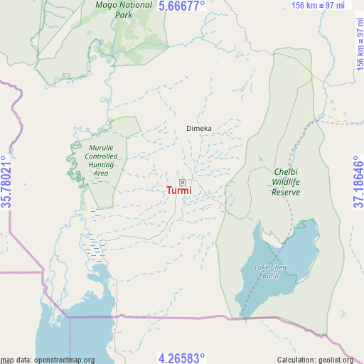
Turmi GPS coordinates[2]
4° 58' 0.012" North, 36° 28' 59.988" East
| Map corner | latitude | longitude |
|---|---|---|
| Upper-left | 5.66677°, | 35.78021° |
| Center: | 4.96667°, | 36.48333° |
| Lower-right: | 4.26583°, | 37.18646° |
| Map W x H: | 155.8×155.8 km | = 96.8×96.8mi |
| max Lat: | 14.277° ⇑97.2% North |
| Turmi: | 4.96667° |
| min Lat: | ⇓2.8% South 4.05° |
| min Long | Turmi | max Long |
| 34.53333° | 36.48333° | 42.8° |
| W 12.1%⇐ | ⇒87.9% E |
Elevation
Elevation of Turmi is 917 m = 3009 ft, and this is 978.6 m = 3211 ft below average elevation for this country.
| Max E: |
2854 m = 9364 ft | 94.4% |
| Avg. | 1895.6 m = 6219 ft | |
| Turmi | 917 m = 3009 ft | |
Min E: |
367 m = 1204 ft | 5.6% |
See also: Ethiopia elevation on elevation.city.
Geographical zone
Turmi is located in North Torrid zone (between Equator and Tropic of Cancer). Distance of Equator is 552.2 km =343.1 mi to South.| Distance of | km | miles | from Turmi |
|---|---|---|---|
| North Pole | 9454.8 | 5874.9 | to North |
| Arctic Circle | 6848.9 | 4255.7 | to North |
| Tropic Cancer | 2053.7 | 1276.1 | to North |
| Equator | 552.2 | 343.1 | to South |


Nearby cities:
15 places around Turmi: (largest is in red/bold)
• Arba Minch
167.3 km =104 mi,  44°
44°
• Bako
91.3 km =56.7 mi,  5°
5°
• Bonga
259.1 km =161 mi,  353°
353°
• Dīla
259.1 km =161 mi,  51°
51°
• Felege Neway
154.7 km =96.1 mi,  16°
16°
• Gīdolē
123.8 km =76.9 mi, 52°
• Hagere Maryam
207.8 km =129.1 mi,  69°
69°
• Jinka
78.2 km =48.6 mi, 13°
• Konso
115.1 km =71.5 mi, 74°
• Lobuni
45 km =28 mi,  250°
250°
• Mēga
225.7 km =140.2 mi,  116°
116°
• Mīzan Teferī
246.6 km =153.2 mi,  336°
336°
• Sodo
253.6 km =157.6 mi,  33°
33°
• Yabēlo
177.5 km =110.3 mi,  92°
92°
• Āreka
269.5 km =167.5 mi, 29°
Sources, notices
• [Note1] Compared only with cities in Ethiopia existing in our database
• [Src1] Map data: © OpenStreetMap contributors (CC-BY-SA)
• [Src2] Other city data from geonames.org with taken over terms of usage.
• [Src3] Geographical zone / Annual Mean Temperature by Robert A. Rohde @ Wikipedia
