Bako geodata
Bako (SNNPR) is a populated place; located in Ethiopia in Africa/Addis_Ababa (GMT+3) time zone. With population of 17,872 people, there are 70 cities with bigger population in this country. Compared to other cities in Ethiopia, 91.6% of cities are located further ↑North; 86.9% of cities are located further →East and 86% of cities have higher elevation than Bako. Note1


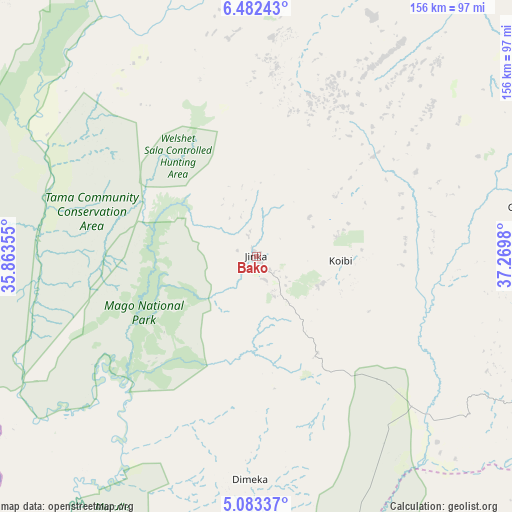
Bako GPS coordinates[2]
5° 46' 59.988" North, 36° 34' 0.012" East
| Map corner | latitude | longitude |
|---|---|---|
| Upper-left | 6.48243°, | 35.86355° |
| Center: | 5.78333°, | 36.56667° |
| Lower-right: | 5.08337°, | 37.2698° |
| Map W x H: | 155.6×155.6 km | = 96.7×96.7mi |
| max Lat: | 14.277° ⇑91.6% North |
| Bako: | 5.78333° |
| min Lat: | ⇓8.4% South 4.05° |
| min Long | Bako | max Long |
| 34.53333° | 36.56667° | 42.8° |
| W 13.1%⇐ | ⇒86.9% E |
Elevation
Elevation of Bako is 1401 m = 4596 ft, and this is 494.6 m = 1623 ft below average elevation for this country.
| Max E: |
2854 m = 9364 ft | 86% |
| Avg. | 1895.6 m = 6219 ft | |
| Bako | 1401 m = 4596 ft | |
Min E: |
367 m = 1204 ft | 14% |
See also: Ethiopia elevation on elevation.city.
Geographical zone
Bako is located in North Torrid zone (between Equator and Tropic of Cancer). Distance of Equator is 643 km =399.5 mi to South.| Distance of | km | miles | from Bako |
|---|---|---|---|
| North Pole | 9364 | 5818.5 | to North |
| Arctic Circle | 6758.1 | 4199.3 | to North |
| Tropic Cancer | 1962.9 | 1219.7 | to North |
| Equator | 643 | 399.5 | to South |


Nearby cities:
15 places around Bako: (largest is in red/bold)
• Arba Minch
112.3 km =69.8 mi,  75°
75°
• Bodītī
194.8 km =121 mi,  47°
47°
• Bonga
170.8 km =106.1 mi,  347°
347°
• Felege Neway
67.3 km =41.8 mi,  31°
31°
• Gīdolē
89.7 km =55.7 mi,  99°
99°
• Hagere Maryam
185.4 km =115.2 mi, 95°
• Jinka
17.5 km =10.9 mi,  148°
148°
• Konso
117.5 km =73 mi,  120°
120°
• Lobuni
117.6 km =73.1 mi,  206°
206°
• Mīzan Teferī
173 km =107.5 mi,  321°
321°
• Sodo
178.2 km =110.7 mi, 47°
• Tippi
200.1 km =124.3 mi, 321°
• Turmi
91.3 km =56.7 mi,  185°
185°
• Yabēlo
195.5 km =121.5 mi, 120°
• Āreka
189.8 km =117.9 mi,  41°
41°
Sources, notices
• [Note1] Compared only with cities in Ethiopia existing in our database
• [Src1] Map data: © OpenStreetMap contributors (CC-BY-SA)
• [Src2] Other city data from geonames.org with taken over terms of usage.
• [Src3] Geographical zone / Annual Mean Temperature by Robert A. Rohde @ Wikipedia
