Jinka geodata
Jinka (SNNPR) is a populated place; located in Ethiopia in Africa/Addis_Ababa (GMT+3) time zone. With population of 32,115 people, there are 35 cities with bigger population in this country. Compared to other cities in Ethiopia, 94.4% of cities are located further ↑North; 86% of cities are located further →East and 84.1% of cities have higher elevation than Jinka. Note1


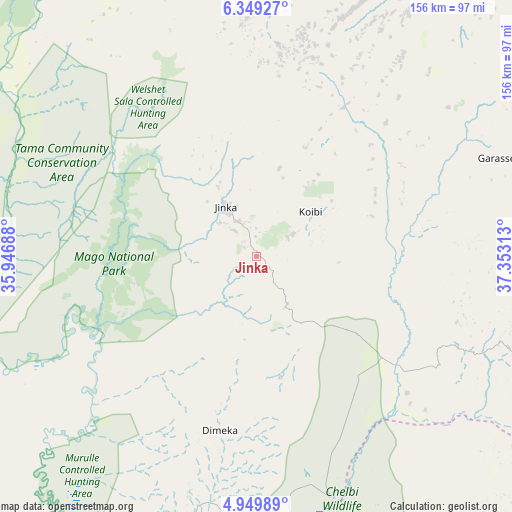
Jinka GPS coordinates[2]
5° 39' 0" North, 36° 39' 0" East
| Map corner | latitude | longitude |
|---|---|---|
| Upper-left | 6.34927°, | 35.94688° |
| Center: | 5.65°, | 36.65° |
| Lower-right: | 4.94989°, | 37.35313° |
| Map W x H: | 155.6×155.6 km | = 96.7×96.7mi |
| max Lat: | 14.277° ⇑94.4% North |
| Jinka: | 5.65° |
| min Lat: | ⇓5.6% South 4.05° |
| min Long | Jinka | max Long |
| 34.53333° | 36.65° | 42.8° |
| W 14%⇐ | ⇒86% E |
Elevation
Elevation of Jinka is 1430 m = 4692 ft, and this is 465.6 m = 1528 ft below average elevation for this country.
| Max E: |
2854 m = 9364 ft | 84.1% |
| Avg. | 1895.6 m = 6219 ft | |
| Jinka | 1430 m = 4692 ft | |
Min E: |
367 m = 1204 ft | 15.9% |
See also: Ethiopia elevation on elevation.city.
Geographical zone
Jinka is located in North Torrid zone (between Equator and Tropic of Cancer). Distance of Equator is 628.2 km =390.3 mi to South.| Distance of | km | miles | from Jinka |
|---|---|---|---|
| North Pole | 9378.8 | 5827.7 | to North |
| Arctic Circle | 6773 | 4208.5 | to North |
| Tropic Cancer | 1977.7 | 1228.9 | to North |
| Equator | 628.2 | 390.3 | to South |


Nearby cities:
15 places around Jinka: (largest is in red/bold)
• Arba Minch
108.3 km =67.3 mi,  66°
66°
• Bako
17.5 km =10.9 mi,  328°
328°
• Bodītī
198.8 km =123.5 mi,  42°
42°
• Bonga
187.4 km =116.4 mi,  345°
345°
• Dīla
203 km =126.1 mi, 65°
• Felege Neway
76.7 km =47.7 mi,  19°
19°
• Gīdolē
79.3 km =49.3 mi,  90°
90°
• Hagere Maryam
175.5 km =109.1 mi, 90°
• Konso
102.4 km =63.6 mi,  115°
115°
• Lobuni
109.3 km =67.9 mi,  213°
213°
• Mīzan Teferī
190.4 km =118.3 mi,  321°
321°
• Sodo
182.2 km =113.2 mi, 42°
• Turmi
78.2 km =48.6 mi,  193°
193°
• Yabēlo
180.1 km =111.9 mi, 118°
• Āreka
195.6 km =121.5 mi, 36°
Sources, notices
• [Note1] Compared only with cities in Ethiopia existing in our database
• [Src1] Map data: © OpenStreetMap contributors (CC-BY-SA)
• [Src2] Other city data from geonames.org with taken over terms of usage.
• [Src3] Geographical zone / Annual Mean Temperature by Robert A. Rohde @ Wikipedia
