Shashemenē geodata
Shashemenē (Oromiya) is a populated place; located in Ethiopia in Africa/Addis_Ababa (GMT+3) time zone. With population of 85,871 people, there are 13 cities with bigger population in this country. Compared to other cities in Ethiopia, 73.8% of cities are located further ↑North; 56.1% of cities are located further ←West and 53.3% of cities have lower elevation than Shashemenē. Note1


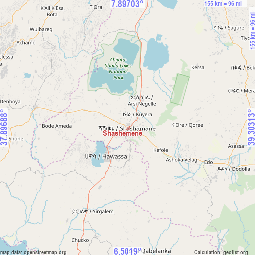
Shashemenē GPS coordinates[2]
7° 12' 0" North, 38° 36' 0" East
| Map corner | latitude | longitude |
|---|---|---|
| Upper-left | 7.89703°, | 37.89688° |
| Center: | 7.2°, | 38.6° |
| Lower-right: | 6.5019°, | 39.30313° |
| Map W x H: | 155.1×155.1 km | = 96.4×96.4mi |
| max Lat: | 14.277° ⇑73.8% North |
| Shashemenē: | 7.2° |
| min Lat: | ⇓26.2% South 4.05° |
| min Long | Shashemenē | max Long |
| 34.53333° | 38.6° | 42.8° |
| W 56.1%⇐ | ⇒43.9% E |
Elevation
Elevation of Shashemenē is 1924 m = 6312 ft, and this is 28.4 m = 93 ft above average elevation for this country.
| Max E: |
2854 m = 9364 ft | 46.7% |
| Shashemenē | 1924 m 6312 ft | |
| Avg. | 1895.6 m = 6219 ft | |
Min E: |
367 m = 1204 ft | 53.3% |
See also: Shashemenē elevation on elevation.city.
Geographical zone
Shashemenē is located in North Torrid zone (between Equator and Tropic of Cancer). Distance of Equator is 800.6 km =497.5 mi to South.| Distance of | km | miles | from Shashemenē |
|---|---|---|---|
| North Pole | 9206.5 | 5720.7 | to North |
| Arctic Circle | 6600.6 | 4101.4 | to North |
| Tropic Cancer | 1805.4 | 1121.8 | to North |
| Equator | 800.6 | 497.5 | to South |


Nearby cities:
15 places around Shashemenē: (largest is in red/bold)
• Bodītī
85 km =52.8 mi,  252°
252°
• Dodola
68.7 km =42.7 mi,  110°
110°
• Dīla
92.5 km =57.5 mi,  199°
199°
• Hawassa
20.5 km =12.7 mi,  221°
221°
• Hosa’ina
91 km =56.5 mi,  295°
295°
• Hāgere Selam
80.2 km =49.8 mi,  186°
186°
• Kofelē
25.1 km =15.6 mi,  126°
126°
• K’olīto
58.4 km =36.3 mi,  282°
282°
• Leku
40.2 km =25 mi,  205°
205°
• Sodo
99.9 km =62.1 mi, 247°
• Wendo
69.7 km =43.3 mi, 196°
• Yirga ‘Alem
54 km =33.6 mi, 202°
• Ziway
82.5 km =51.3 mi,  8°
8°
• Āreka
100.4 km =62.4 mi,  261°
261°
• Āsasa
67.1 km =41.7 mi,  99°
99°
Sources, notices
• [Note1] Compared only with cities in Ethiopia existing in our database
• [Src1] Map data: © OpenStreetMap contributors (CC-BY-SA)
• [Src2] Other city data from geonames.org with taken over terms of usage.
• [Src3] Geographical zone / Annual Mean Temperature by Robert A. Rohde @ Wikipedia
