Leku geodata
Leku (SNNPR) is a populated place; located in Ethiopia in Africa/Addis_Ababa (GMT+3) time zone. With population of 11,398 people, there are 87 cities with bigger population in this country. Compared to other cities in Ethiopia, 83.2% of cities are located further ↑North; 52.3% of cities are located further ←West and 55.1% of cities have higher elevation than Leku. Note1


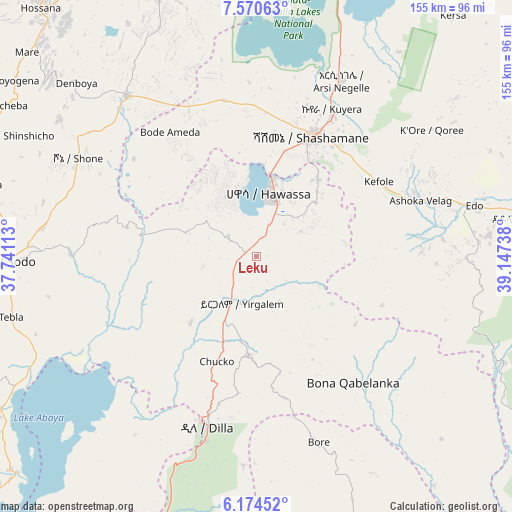
Leku GPS coordinates[2]
6° 52' 23.124" North, 38° 26' 39.3" East
| Map corner | latitude | longitude |
|---|---|---|
| Upper-left | 7.57063°, | 37.74113° |
| Center: | 6.87309°, | 38.44425° |
| Lower-right: | 6.17452°, | 39.14738° |
| Map W x H: | 155.2×155.2 km | = 96.4×96.4mi |
| max Lat: | 14.277° ⇑83.2% North |
| Leku: | 6.87309° |
| min Lat: | ⇓16.8% South 4.05° |
| min Long | Leku | max Long |
| 34.53333° | 38.44425° | 42.8° |
| W 52.3%⇐ | ⇒47.7% E |
Elevation
Elevation of Leku is 1873 m = 6145 ft, and this is 22.6 m = 74 ft below average elevation for this country.
| Max E: |
2854 m = 9364 ft | 55.1% |
| Avg. | 1895.6 m = 6219 ft | |
| Leku | 1873 m = 6145 ft | |
Min E: |
367 m = 1204 ft | 44.9% |
See also: Ethiopia elevation on elevation.city.
Geographical zone
Leku is located in North Torrid zone (between Equator and Tropic of Cancer). Distance of Equator is 764.2 km =474.9 mi to South.| Distance of | km | miles | from Leku |
|---|---|---|---|
| North Pole | 9242.8 | 5743.2 | to North |
| Arctic Circle | 6637 | 4124 | to North |
| Tropic Cancer | 1841.7 | 1144.4 | to North |
| Equator | 764.2 | 474.9 | to South |


Nearby cities:
15 places around Leku: (largest is in red/bold)
• Bodītī
64.6 km =40.1 mi,  279°
279°
• Dodola
82.5 km =51.3 mi,  81°
81°
• Dīla
52.7 km =32.7 mi,  195°
195°
• Hawassa
21.3 km =13.2 mi,  9°
9°
• Hosa’ina
99.5 km =61.8 mi,  319°
319°
• Hāgere Selam
44.1 km =27.4 mi,  169°
169°
• Kofelē
43.2 km =26.8 mi,  60°
60°
• K’olīto
63.4 km =39.4 mi, 321°
• Shashemenē
40.2 km =25 mi,  25°
25°
• Sodo
75.4 km =46.9 mi,  268°
268°
• Wendo
30.5 km =19 mi,  185°
185°
• Yirga ‘Alem
14 km =8.7 mi, 192°
• Ziway
121.7 km =75.6 mi, 14°
• Āreka
84.9 km =52.8 mi, 284°
• Āsasa
87.1 km =54.1 mi,  73°
73°
Sources, notices
• [Note1] Compared only with cities in Ethiopia existing in our database
• [Src1] Map data: © OpenStreetMap contributors (CC-BY-SA)
• [Src2] Other city data from geonames.org with taken over terms of usage.
• [Src3] Geographical zone / Annual Mean Temperature by Robert A. Rohde @ Wikipedia
