Ziway geodata
Ziway (Oromiya) is a populated place; located in Ethiopia in Africa/Addis_Ababa (GMT+3) time zone. With population of 49,416 people, there are 21 cities with bigger population in this country. Compared to other cities in Ethiopia, 67.3% of cities are located further ↑North; 57.9% of cities are located further ←West and 74.8% of cities have higher elevation than Ziway. Note1


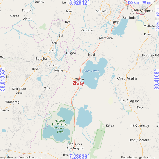
Ziway GPS coordinates[2]
7° 55' 59.988" North, 38° 43' 0.012" East
| Map corner | latitude | longitude |
|---|---|---|
| Upper-left | 8.62912°, | 38.01355° |
| Center: | 7.93333°, | 38.71667° |
| Lower-right: | 7.23636°, | 39.4198° |
| Map W x H: | 154.9×154.9 km | = 96.3×96.3mi |
| max Lat: | 14.277° ⇑67.3% North |
| Ziway: | 7.93333° |
| min Lat: | ⇓32.7% South 4.05° |
| min Long | Ziway | max Long |
| 34.53333° | 38.71667° | 42.8° |
| W 57.9%⇐ | ⇒42.1% E |
Elevation
Elevation of Ziway is 1649 m = 5410 ft, and this is 246.6 m = 809 ft below average elevation for this country.
| Max E: |
2854 m = 9364 ft | 74.8% |
| Avg. | 1895.6 m = 6219 ft | |
| Ziway | 1649 m = 5410 ft | |
Min E: |
367 m = 1204 ft | 25.2% |
See also: Ziway elevation on elevation.city.
Geographical zone
Ziway is located in North Torrid zone (between Equator and Tropic of Cancer). Distance of Equator is 882.1 km =548.1 mi to South.| Distance of | km | miles | from Ziway |
|---|---|---|---|
| North Pole | 9125 | 5670 | to North |
| Arctic Circle | 6519.1 | 4050.8 | to North |
| Tropic Cancer | 1723.8 | 1071.1 | to North |
| Equator | 882.1 | 548.1 | to South |


Nearby cities:
15 places around Ziway: (largest is in red/bold)
• Bishoftu
95.5 km =59.3 mi,  17°
17°
• Butajīra
43.6 km =27.1 mi,  297°
297°
• Hawassa
100.4 km =62.4 mi,  195°
195°
• Hosa’ina
104.2 km =64.7 mi,  245°
245°
• Huruta
73.8 km =45.9 mi,  70°
70°
• Kofelē
96.6 km =60 mi,  175°
175°
• K’olīto
97.8 km =60.8 mi,  225°
225°
• Mojo
85.2 km =52.9 mi,  31°
31°
• Nazrēt
91.5 km =56.9 mi,  41°
41°
• Shashemenē
82.5 km =51.3 mi,  188°
188°
• Sirre
94.5 km =58.7 mi,  63°
63°
• Tulu Bolo
98.4 km =61.1 mi,  325°
325°
• Waliso
106.3 km =66.1 mi,  308°
308°
• Wenjī
84.8 km =52.7 mi,  47°
47°
• Āsasa
106.9 km =66.4 mi,  150°
150°
Sources, notices
• [Note1] Compared only with cities in Ethiopia existing in our database
• [Src1] Map data: © OpenStreetMap contributors (CC-BY-SA)
• [Src2] Other city data from geonames.org with taken over terms of usage.
• [Src3] Geographical zone / Annual Mean Temperature by Robert A. Rohde @ Wikipedia
