Kofelē geodata
Kofelē (Oromiya) is a populated place; located in Ethiopia in Africa/Addis_Ababa (GMT+3) time zone. With population of 9,643 people, there are 95 cities with bigger population in this country. Compared to other cities in Ethiopia, 77.6% of cities are located further ↑North; 61.7% of cities are located further ←West and 92.5% of cities have lower elevation than Kofelē. Note1


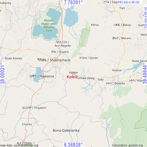
Kofelē GPS coordinates[2]
7° 4' 0.012" North, 38° 46' 59.988" East
| Map corner | latitude | longitude |
|---|---|---|
| Upper-left | 7.76391°, | 38.08021° |
| Center: | 7.06667°, | 38.78333° |
| Lower-right: | 6.36838°, | 39.48646° |
| Map W x H: | 155.2×155.2 km | = 96.4×96.4mi |
| max Lat: | 14.277° ⇑77.6% North |
| Kofelē: | 7.06667° |
| min Lat: | ⇓22.4% South 4.05° |
| min Long | Kofelē | max Long |
| 34.53333° | 38.78333° | 42.8° |
| W 61.7%⇐ | ⇒38.3% E |
Elevation
Elevation of Kofelē is 2666 m = 8747 ft, and this is 770.4 m = 2528 ft above average elevation for this country.
| Max E: |
2854 m = 9364 ft | 7.5% |
| Kofelē | 2666 m 8747 ft | |
| Avg. | 1895.6 m = 6219 ft | |
Min E: |
367 m = 1204 ft | 92.5% |
See also: Ethiopia elevation on elevation.city.
Geographical zone
Kofelē is located in North Torrid zone (between Equator and Tropic of Cancer). Distance of Equator is 785.7 km =488.2 mi to South.| Distance of | km | miles | from Kofelē |
|---|---|---|---|
| North Pole | 9221.3 | 5729.8 | to North |
| Arctic Circle | 6615.4 | 4110.6 | to North |
| Tropic Cancer | 1820.2 | 1131 | to North |
| Equator | 785.7 | 488.2 | to South |


Nearby cities:
15 places around Kofelē: (largest is in red/bold)
• Bodītī
101.8 km =63.3 mi,  263°
263°
• Dodola
45.1 km =28 mi,  101°
101°
• Dīla
88.8 km =55.2 mi,  215°
215°
• Hawassa
33.9 km =21.1 mi,  269°
269°
• Hosa’ina
115.7 km =71.9 mi,  297°
297°
• Hāgere Selam
71.2 km =44.2 mi,  204°
204°
• K’olīto
82.1 km =51 mi,  289°
289°
• Leku
43.2 km =26.8 mi,  240°
240°
• Shashemenē
25.1 km =15.6 mi,  306°
306°
• Sodo
115.1 km =71.5 mi, 258°
• Wendo
65.8 km =40.9 mi, 217°
• Yirga ‘Alem
53.6 km =33.3 mi,  228°
228°
• Ziway
96.6 km =60 mi,  355°
355°
• Āreka
119.5 km =74.3 mi, 270°
• Āsasa
46.1 km =28.6 mi,  85°
85°
Sources, notices
• [Note1] Compared only with cities in Ethiopia existing in our database
• [Src1] Map data: © OpenStreetMap contributors (CC-BY-SA)
• [Src2] Other city data from geonames.org with taken over terms of usage.
• [Src3] Geographical zone / Annual Mean Temperature by Robert A. Rohde @ Wikipedia
