Thiron Gardais geodata
Thiron Gardais (Centre) is a populated place; located in France in Europe/Paris (GMT+2) time zone. With population of 1,157 people, there are 7785 cities with bigger population in this country. Compared to other cities in France, 64.9% of cities are located further ↓South; 68.9% of cities are located further →East and 74.4% of cities have lower elevation than Thiron Gardais. Note1
Administrative division(s):
- Level 1: Centre
- Level 2: Département d'Eure-et-Loir
- Level 3: Arrondissement de Nogent-le-Rotrou
- Level 4: Thiron-Gardais


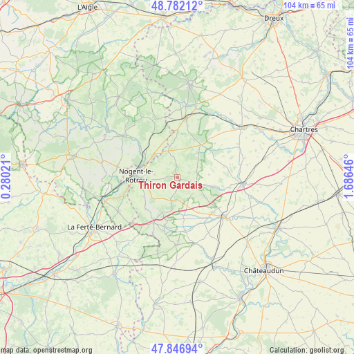
Thiron Gardais GPS coordinates[2]
48° 19' 0.012" North, 0° 58' 59.988" East
| Map corner | latitude | longitude |
|---|---|---|
| Upper-left | 48.78212°, | 0.28021° |
| Center: | 48.31667°, | 0.98333° |
| Lower-right: | 47.84694°, | 1.68646° |
| Map W x H: | 104×104 km | = 64.6×64.6mi |
| max Lat: | 51.07786° ⇑35.1% North |
| Thiron Gardais: | 48.31667° |
| min Lat: | ⇓64.9% South 41.3874° |
| min Long | Thiron Gardais | max Long |
| -5.08615° | 0.98333° | 9.52242° |
| W 31.1%⇐ | ⇒68.9% E |
Elevation
Elevation of Thiron Gardais is 245 m = 804 ft, and this is 51.3 m = 168 ft above average elevation for this country.
| Max E: |
2333 m = 7654 ft | 25.6% |
| Thiron Gardais | 245 m 804 ft | |
| Avg. | 193.7 m = 635 ft | |
Min E: |
-1 m = -3 ft | 74.4% |
See also: France elevation on elevation.city.
Geographical zone
Thiron Gardais is located in North temperate zone (between Tropic of Cancer and the Arctic Circle). Distance of this North polar circle is 2028.9 km =1260.7 mi to North.| Distance of | km | miles | from Thiron Gardais |
|---|---|---|---|
| North Pole | 4634.8 | 2879.9 | to North |
| Arctic Circle | 2028.9 | 1260.7 | to North |
| Tropic Cancer | 2766.4 | 1719 | to South |
| Equator | 5372.3 | 3338.2 | to South |


Nearby cities:
15 places around Thiron Gardais: (largest is in red/bold)
• Authon-du-Perche
15 km =9.3 mi,  206°
206°
• Beaumont-les-Autels
6.8 km =4.2 mi,  195°
195°
• Bretoncelles
14.6 km =9.1 mi,  331°
331°
• Brou
17.4 km =10.8 mi,  129°
129°
• Brunelles
6.7 km =4.2 mi,  277°
277°
• Condé-sur-Huisne
12.1 km =7.5 mi,  306°
306°
• Frazé
10.6 km =6.6 mi, 125°
• La Loupe
17.6 km =10.9 mi,  7°
7°
• Margon
11.2 km =7 mi, 280°
• Mâle
18.8 km =11.7 mi,  254°
254°
• Nogent-le-Rotrou
12 km =7.5 mi,  272°
272°
• Saint-Hilaire-sur-Erre
18.1 km =11.2 mi, 268°
• Saint-Éliph
15.2 km =9.4 mi, 11°
• Souancé-au-Perche
11 km =6.8 mi,  239°
239°
• Unverre
15.4 km =9.6 mi,  148°
148°
Sources, notices
• [Note1] Compared only with cities in France existing in our database
• [Src1] Map data: © OpenStreetMap contributors (CC-BY-SA)
• [Src2] Other city data from geonames.org with taken over terms of usage.
• [Src3] Geographical zone / Annual Mean Temperature by Robert A. Rohde @ Wikipedia
